IMAGES TAKEN NEAR TO
Meon Hill, STRATFORD-UPON-AVON, CV37 8QT
Introduction
This page details the photographs taken nearby to Meon Hill, CV37 8QT by members of the Geograph project.
The Geograph project started in 2005 with the aim of publishing, organising and preserving representative images for every square kilometre of Great Britain, Ireland and the Isle of Man.

There are currently over 7.5m images from over14,400 individuals and you can help contribute to the project by visiting https://www.geograph.org.uk
Image Map (Loading...)


Getting Data...Please wait
Leaflet Map data © OpenStreetMap
Images are licensed for reuse under creativecommons.org/licenses/by-sa/2.0
Notes
- Clicking on the map will re-center to the selected point.
- The higher the marker number, the further away the image location is from the centre of the postcode.
Image Listing (12 Images Found)
Images are licensed for reuse under creativecommons.org/licenses/by-sa/2.0
Image
Details
Distance
1
Farm at Lower Meon
Lower Meon viewed from the west. The farm is not named on the OS map other than simply Lower Meon
Image: © Philip Halling
Taken: 2 Feb 2008
0.01 miles
2
Lower Meon
A sizeable working farm with associated farm buildings on the lower slopes of Meon Hill.
Image: © Nigel Mykura
Taken: 12 Feb 2012
0.02 miles
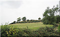
3
Lower Meon
The farm at Lower Meon sits in the shadow of Meon Hill, a northerly outcrop of the Cotswolds.
Image: © Stephen McKay
Taken: 27 May 2009
0.03 miles
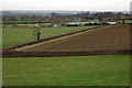
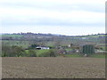
4
Lower Meon
The farm is seen from the footpath that is part of both the Monarch's Way and the Centenary Way. In the distance the land rises to Crimscote Downs.
Image: © Michael Dibb
Taken: 4 Dec 2011
0.04 miles
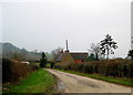
5
Lower Meon
The gateway to the farm at Lower Meon from the Hidcote - Lower Quinton Road has a good view to Meon Hill. Although largely forgotten now, Meon Hill was the site of a strange murder in 1945 that had strong overtones of witchcraft. An elderly farmworker was discovered on the hill one February night pinned to the ground by his pitchfork and with a cross carved into his chest. Despite an intensive inquiry the police were unable to make any progress and the murder remains unsolved to this day. The full story is told here: http://www.bbc.co.uk/coventry/content/articles/2006/06/26/weird_witchcraft_murder_feature.shtml
Image: © Stephen McKay
Taken: 27 May 2009
0.04 miles
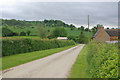
6
Meon Hill
Meon Hill, looking west from the Hidcote to Quinton road.
Image: © Dave Bushell
Taken: 3 Oct 2005
0.21 miles
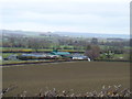
7
Towards the road
This view is seen from the combined Monarch's Way and Centenary Way. The barns are part of Lower Meon Farm and the white building is The Bungalow located alongside the minor road. On the skyline in the far distance is Highwall Spinney atop Brailes Hill some 8 miles away Image
Image: © Michael Dibb
Taken: 4 Dec 2011
0.21 miles
8
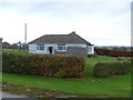
The Bungalow
The Bungalow is alongside the minor road and enjoys a pleasant outlook.
Image: © Michael Dibb
Taken: 4 Dec 2011
0.21 miles
9
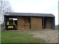
Well stocked barn
This barn is alongside the driveway to Meon Hall which is part of both the Centenary Way and the Monarch's Way. The barn is well filled with bales and machinery.
Image: © Michael Dibb
Taken: 4 Dec 2011
0.22 miles
10
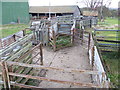
Animal pens
These pens are alongside the driveway to Meon Hall which is part of both the Monarch's Way and Centenary Way long distance paths.
Image: © Michael Dibb
Taken: 4 Dec 2011
0.22 miles