IMAGES TAKEN NEAR TO
Wimpstone, STRATFORD-UPON-AVON, CV37 8NT
Introduction
This page details the photographs taken nearby to Wimpstone, CV37 8NT by members of the Geograph project.
The Geograph project started in 2005 with the aim of publishing, organising and preserving representative images for every square kilometre of Great Britain, Ireland and the Isle of Man.

There are currently over 7.5m images from over14,400 individuals and you can help contribute to the project by visiting https://www.geograph.org.uk
Image Map (Loading...)


Getting Data...Please wait
Leaflet Map data © OpenStreetMap
Images are licensed for reuse under creativecommons.org/licenses/by-sa/2.0
Notes
- Clicking on the map will re-center to the selected point.
- The higher the marker number, the further away the image location is from the centre of the postcode.
Image Listing (13 Images Found)
Images are licensed for reuse under creativecommons.org/licenses/by-sa/2.0
Image
Details
Distance
1
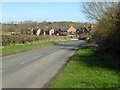
Houses on Wimpstone Lane
Houses on Wimpstone Lane in the village of Wimpstone, viewed here from the crossroads in the village.
Image: © Philip Halling
Taken: 9 Mar 2017
0.12 miles
3
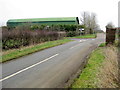
Wimpstone Crossroads
Looking south east along the Preston to Crimscote road where it crosses Redhill Bank by the village. The barn is part of Middle Wympson farm which is an interesting corruption of the village name.
Image: © Nigel Mykura
Taken: 12 Feb 2012
0.13 miles
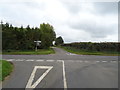
4
Crossroads at Wimpstone
Crossroads on the western edge of the small village of Wimpstone.
Image: © Philip Halling
Taken: 9 Mar 2017
0.13 miles
5
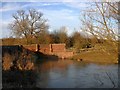
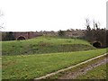
Bridge over the Stour at Wimpstone
View North in the low winter afternoon sun.
Image: © David P Howard
Taken: 26 Feb 2010
0.17 miles
6
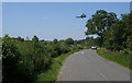
Shakespeare's Way
Shakespeare's Way on Wimpstone Lane with a Puma helicopter passing over
Image: © Shaun Ferguson
Taken: 13 Jun 2014
0.20 miles
7
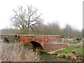
Wimpstone Bridge
A simple red brick single deep arch bridge over the River Stour just north of the village
Image: © Nigel Mykura
Taken: 12 Feb 2012
0.20 miles
8
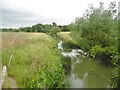
Wimpstone, River Stour
Looking upstream from Wimpstone Bridge.
Image: © Mike Faherty
Taken: 28 Jul 2017
0.21 miles
9
River/road bridge left
Left: road bridge over R.Stour and right: overflow bridge to drain adjoining land, near metering station
Image: © Liz Stone
Taken: 11 Jan 2011
0.21 miles
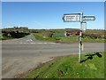
10
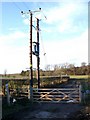
Footpath to Alscot Park
View North where the footpath leaves Wimpstone Lane. Note the large transformer on two poles.
Image: © David P Howard
Taken: 26 Feb 2010
0.21 miles