IMAGES TAKEN NEAR TO
Shipston Road, STRATFORD-UPON-AVON, CV37 8LY
Introduction
This page details the photographs taken nearby to Shipston Road, CV37 8LY by members of the Geograph project.
The Geograph project started in 2005 with the aim of publishing, organising and preserving representative images for every square kilometre of Great Britain, Ireland and the Isle of Man.

There are currently over 7.5m images from over14,400 individuals and you can help contribute to the project by visiting https://www.geograph.org.uk
Image Map (Loading...)


Getting Data...Please wait
Leaflet Map data © OpenStreetMap
Images are licensed for reuse under creativecommons.org/licenses/by-sa/2.0
Notes
- Clicking on the map will re-center to the selected point.
- The higher the marker number, the further away the image location is from the centre of the postcode.
Image Listing (14 Images Found)
Images are licensed for reuse under creativecommons.org/licenses/by-sa/2.0
Image
Details
Distance
1
![Springfield House [2]](https://s1.geograph.org.uk/geophotos/02/77/16/2771621_666bd776_120x120.jpg)
Springfield House [2]
The house is seen from the entrance driveway, a public footpath.
Image: © Michael Dibb
Taken: 6 Nov 2011
0.01 miles
2
![Springfield House [1]](https://s1.geograph.org.uk/geophotos/02/77/16/2771601_f11307db_120x120.jpg)
Springfield House [1]
Seen from the footpath, the house offers bed and breakfast accommodation.
Image: © Michael Dibb
Taken: 6 Nov 2011
0.01 miles
3
![Listed bridge [1]](https://s3.geograph.org.uk/geophotos/02/77/16/2771615_704a86d2_120x120.jpg)
Listed bridge [1]
The entrance to Springfield House is also the start of the footpath to Clifford Chambers. Immediately after leaving the road, the driveway crosses a bridge over the former Moreton-in-Marsh to Stratford-upon-Avon tramway. The bridge is listed grade II and further details are at http://www.britishlistedbuildings.co.uk/en-366408-springfield-bridge-stratford-upon-avon
Image: © Michael Dibb
Taken: 6 Nov 2011
0.04 miles
4
![Listed bridge [2]](https://s3.geograph.org.uk/geophotos/02/77/16/2771627_f96b2635_120x120.jpg)
Listed bridge [2]
The entrance driveway to Springfield House crosses this bridge over the former Moreton-in-Marsh to Stratford-upon-Avon tramway. The bridge, seen from the footpath, is listed grade II and further details are at http://www.britishlistedbuildings.co.uk/en-366408-springfield-bridge-stratford-upon-avon
Image: © Michael Dibb
Taken: 6 Nov 2011
0.04 miles
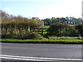
5
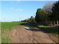
Near Springfield House
The track, a public footpath, heads towards the A3400 road. The fenced area on the right is the garden of Springfield House.
Image: © Michael Dibb
Taken: 6 Nov 2011
0.08 miles
6

View from Shipston Road
Looking west across the plain of the Stour as it approaches its confluence with the River Avon just to the west of Stratford-upon-Avon. In the distance is Atherston Hill.
Image: © David Stowell
Taken: 13 Dec 2005
0.15 miles
8
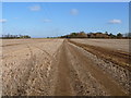
Straight line path
The track, a public footpath, runs arrow straight across the flat landscape.
Image: © Michael Dibb
Taken: 6 Nov 2011
0.18 miles
9
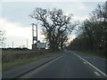
Shipston Road (A3400), heading north
Towards Stratford-upon-Avon.
Image: © JThomas
Taken: 3 Apr 2013
0.18 miles
10
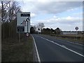
Path meets road
The short footpath from Springfield House and the A3400 meets Clifford Lane, the B4632 (formerly the A46).
Image: © Michael Dibb
Taken: 6 Nov 2011
0.19 miles