IMAGES TAKEN NEAR TO
Milcote Road, STRATFORD-UPON-AVON, CV37 8JX
Introduction
This page details the photographs taken nearby to Milcote Road, CV37 8JX by members of the Geograph project.
The Geograph project started in 2005 with the aim of publishing, organising and preserving representative images for every square kilometre of Great Britain, Ireland and the Isle of Man.

There are currently over 7.5m images from over14,400 individuals and you can help contribute to the project by visiting https://www.geograph.org.uk
Image Map (Loading...)


Getting Data...Please wait
Leaflet Map data © OpenStreetMap
Images are licensed for reuse under creativecommons.org/licenses/by-sa/2.0
Notes
- Clicking on the map will re-center to the selected point.
- The higher the marker number, the further away the image location is from the centre of the postcode.
Image Listing (13 Images Found)
Images are licensed for reuse under creativecommons.org/licenses/by-sa/2.0
Image
Details
Distance
1
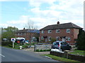
Cottages at Weston
These semi-detached cottages stand on their own just south of the tiny village of Weston. One of them has a very impressive array of solar panels. they have the appearance of having been council houses previously.
Image: © Nigel Mykura
Taken: 16 Apr 2012
0.02 miles
2
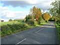
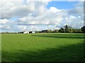
Milcote Road near Weston Sands Farm
Looking ESE along Milcote Road as it heads towards Clifford Chambers. The buildings of Weston Sands Farm are visible on the left.
Image: © David P Howard
Taken: 24 Oct 2010
0.08 miles
3

Green Triangle , Weston
This triangle is at the junction of the road into the village of Weston , which is a dead end and the Milcote road between Welford and Clifford Chambers.
Image: © Nigel Mykura
Taken: 16 Apr 2012
0.12 miles
4
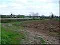
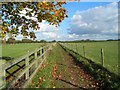
Ploughed field next to the Milcote Rd
This field has retained a wide margin and track next to the hedgerow and ditch. At this point the soils are rich alluvial soils on the Avon floodplain and we are only 3 metres above the level of the river itself.
Image: © Nigel Mykura
Taken: 16 Apr 2012
0.12 miles
5
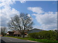
Footpath to Weston-on-Avon
Looking NNW from near to Milcote Road towards the houses on the edge of Weston-on-Avon.
Image: © David P Howard
Taken: 24 Oct 2010
0.17 miles
6
Weston Sands Farm
View ESE from the footpath to Weston-on-Avon towards Weston Sands Farm situated on Milcote Road.
Image: © David P Howard
Taken: 24 Oct 2010
0.20 miles
7
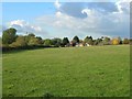
Weston Sands Farm
A large mixed farm just south east of Weston on Avon. The farms fields are mainly on the fertile floodplain of the River Avon.
Image: © Nigel Mykura
Taken: 16 Apr 2012
0.22 miles
8
Bridleway to Clifford Chambers
View east along the bridleway as it leaves Weston-on-Avon heading for Clifford Chambers.
Image: © David P Howard
Taken: 24 Oct 2010
0.22 miles
9

Remains of a cross, Weston-on-Avon
The remains of a preaching cross in the churchyard of All Saints church in Weston-on-Avon.
Image: © Philip Halling
Taken: 29 Mar 2009
0.24 miles
10
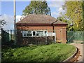
Pumping Station, Weston-on-Avon
Severn Trent Water pumping station next to All Saints' Church.
Image: © David P Howard
Taken: 24 Oct 2010
0.24 miles