IMAGES TAKEN NEAR TO
Barton Road, STRATFORD-UPON-AVON, CV37 8HQ
Introduction
This page details the photographs taken nearby to Barton Road, CV37 8HQ by members of the Geograph project.
The Geograph project started in 2005 with the aim of publishing, organising and preserving representative images for every square kilometre of Great Britain, Ireland and the Isle of Man.

There are currently over 7.5m images from over14,400 individuals and you can help contribute to the project by visiting https://www.geograph.org.uk
Image Map
Images are licensed for reuse under creativecommons.org/licenses/by-sa/2.0
Notes
- Clicking on the map will re-center to the selected point.
- The higher the marker number, the further away the image location is from the centre of the postcode.
Image Listing (4 Images Found)
Images are licensed for reuse under creativecommons.org/licenses/by-sa/2.0
Image
Details
Distance
1
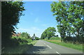
Barton Road Welford-on-Avon approaching blind crest in road
Image: © Roy Hughes
Taken: 16 Jul 2022
0.08 miles
2
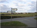
Bunkers Hill sign
The second arm down on the right quite conveniently points to Welford as the sun catches the village itself in the distance.
Image: © David Stowell
Taken: 25 Feb 2006
0.16 miles
3
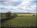
View from Bunkers Hill
Looking north across the flood plain of the River Avon. The river itself flows just beyond the trees at the end of the fields in the foreground.
Image: © David Stowell
Taken: 25 Feb 2006
0.16 miles
4
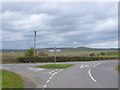
Road Junction
This T junction with a small green triangle is where Braggington Lane meets Barton Lane the minor road from Welford on Avon to Barton and Bidford. The hill in the background is Binton Hill.
Image: © Nigel Mykura
Taken: 14 Apr 2013
0.21 miles