IMAGES TAKEN NEAR TO
Bennetts Rise, CV37 8GS
Introduction
This page details the photographs taken nearby to Bennetts Rise, CV37 8GS by members of the Geograph project.
The Geograph project started in 2005 with the aim of publishing, organising and preserving representative images for every square kilometre of Great Britain, Ireland and the Isle of Man.

There are currently over 7.5m images from over14,400 individuals and you can help contribute to the project by visiting https://www.geograph.org.uk
Image Map
Images are licensed for reuse under creativecommons.org/licenses/by-sa/2.0
Notes
- Clicking on the map will re-center to the selected point.
- The higher the marker number, the further away the image location is from the centre of the postcode.
Image Listing (3 Images Found)
Images are licensed for reuse under creativecommons.org/licenses/by-sa/2.0
Image
Details
Distance
1
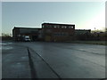
Long Marston storage depot
Building and fuel tanks on the Long Marston storage depot
Image: © Paul Rudge
Taken: 17 Dec 2008
0.10 miles
2
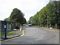
Central Engineer Park Entrance
Entrance from the Stratford to Mickleton road to the former MOD Central Engineer Park at Long Marston. Looking west.
Image: © Dave Bushell
Taken: 22 Sep 2005
0.14 miles
3
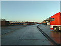
Long Marston storage depot
Road on the Long Marston storage depot
Image: © Paul Rudge
Taken: 17 Dec 2008
0.18 miles