IMAGES TAKEN NEAR TO
Newbold On Stour, STRATFORD-UPON-AVON, CV37 8BY
Introduction
This page details the photographs taken nearby to CV37 8BY by members of the Geograph project.
The Geograph project started in 2005 with the aim of publishing, organising and preserving representative images for every square kilometre of Great Britain, Ireland and the Isle of Man.

There are currently over 7.5m images from over14,400 individuals and you can help contribute to the project by visiting https://www.geograph.org.uk
Image Map (Loading...)


Getting Data...Please wait
Leaflet Map data © OpenStreetMap
Images are licensed for reuse under creativecommons.org/licenses/by-sa/2.0
Notes
- Clicking on the map will re-center to the selected point.
- The higher the marker number, the further away the image location is from the centre of the postcode.
Image Listing (14 Images Found)
Images are licensed for reuse under creativecommons.org/licenses/by-sa/2.0
Image
Details
Distance
1
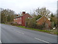
Newbold Wharf Cottages
These undistinguished cottages alongside the A3400 road just north of Newbold-on-Stour were once part of the loading and unloading wharf of the horse drawn tramway from Moreton-in-Marsh to the canal basin at Stratford-upon-Avon built in 1826 with a branch to Shipston-on-Stour. See http://www.warwickshirerailways.com/gwr/mortonshipston.htm for more details.
Image: © Michael Dibb
Taken: 10 Dec 2011
0.01 miles
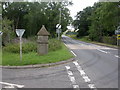
2
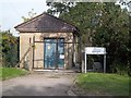
Pumping station
This small water pumping station is alongside the minor road. The addition of (Wharf) to Newbold-on-Stour on the sign comes from the loading/unloading point nearby on the former Moreton-in-Marsh to Stratford-upon-Avon horse-drawn tramway.
Image: © Michael Dibb
Taken: 22 Sep 2010
0.04 miles
3
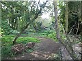
Once a tramway
This is the former trackbed of the tramway between Moreton-in-Marsh and Stratford-upon-Avon. It was built as a horse-drawn tramway with a branch to Shipston-on-Stour. The part between Moreton and Shipston was converted into a standard railway in 1889. Passenger services ceased in 1929, goods traffic ceased in 1960. See http://www.warwickshirerailways.com/gwr/mortonshipston.htm for more details and original photographs. The part from Darlingscott to Stratford remained horse-drawn and fell into disuse by the end of the 19th century. Dismantled in 1916 to feed the war effort, there are many remains to be seen in this area.
Image: © Michael Dibb
Taken: 22 Sep 2010
0.05 miles
4
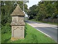
Listed milestone
This milestone, '6 miles to Shakespeare's Town', is a listed building and sits alongside the A3400.
Image: © Michael Dibb
Taken: 22 Sep 2010
0.10 miles
5
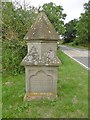
Old Milestone by the A3400, Newbold-on-Stour
Carved stone post by the A3400 (was A34), in parish of Tredington (Stratford on Avon District), 200m North of Newbold village at forked junction with road to Crimscote, on grass verge of forked junction, on West side of road. Probably privately erected by the Shirley family in the 19th century.
Inscription reads:-
6 Miles
To Shakespeare's Town, Whose Name
Is Known throughout the Earth
To Shipston Four, whose lesser Name
Boasts no such Poet's Birth.
Grade II listed. List Entry Number: 1035667
https://historicengland.org.uk/listing/the-list/list-entry/1035667
Milestone Society National ID: WA_SFOX06.
Image: © Milestone Society
Taken: 28 Jul 2017
0.10 miles
6
Newbold-on-Stour, milestone
Unusual milestone at junction A3400 & minor road to Crimscote, presumably privately erected. Square, with two stages; top is pyramidal, and probably originally surmounted by a cross or decoration. On the lower stage are four panels, enclosed in Gothic arches; two bear shields, one a Latin inscription, and the last, shown here, an inscription in blackletter: "6 Miles/To Shakspeare's [sic] Town whose Name/Is known throughout the Earth/To Shipstone 4 whose lesser Fame/Boasts no such Poet's Birth." At the base of the upper stage are Latin lines referring to transience & immortality. English Heritage-listed, http://www.imagesofengland.org.uk/Details/default.aspx?pid=2&id=306649
Image: © Mike Faherty
Taken: 11 Jul 2009
0.10 miles
7
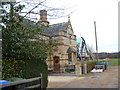
South Lodge
Originally a lodge to Ettington Hall, this grade II listed building has had two extensions added to it. Both of these extensions have their inception date carved on to them (2008 & 2010). More details are at http://www.britishlistedbuildings.co.uk/en-306646-the-lodge-tredington
Image: © Michael Dibb
Taken: 10 Dec 2011
0.11 miles
8
A3400 at Newbold on Stour village boundary
Image: © Colin Pyle
Taken: 27 Feb 2016
0.11 miles
9
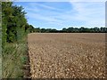
Ripe Wheat field
This field of wheat almost ready to harvest is just off the minor road that leads to Crimscote outside Newbold on Stour.
Image: © Nigel Mykura
Taken: 24 Jul 2011
0.12 miles
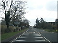
10
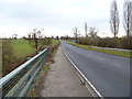
The road to Newbold
Seen from the bridge carrying the A3400 road over the River Stour, this view is looking along the straight stretch of the road towards Newbold-on-Stour.
Image: © Michael Dibb
Taken: 10 Dec 2011
0.19 miles