IMAGES TAKEN NEAR TO
Alderminster, STRATFORD-UPON-AVON, CV37 8BP
Introduction
This page details the photographs taken nearby to CV37 8BP by members of the Geograph project.
The Geograph project started in 2005 with the aim of publishing, organising and preserving representative images for every square kilometre of Great Britain, Ireland and the Isle of Man.

There are currently over 7.5m images from over14,400 individuals and you can help contribute to the project by visiting https://www.geograph.org.uk
Image Map (Loading...)


Getting Data...Please wait
Leaflet Map data © OpenStreetMap
Images are licensed for reuse under creativecommons.org/licenses/by-sa/2.0
Notes
- Clicking on the map will re-center to the selected point.
- The higher the marker number, the further away the image location is from the centre of the postcode.
Image Listing (9 Images Found)
Images are licensed for reuse under creativecommons.org/licenses/by-sa/2.0
Image
Details
Distance
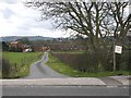
1
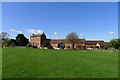
Shakespeare's Way approaching Alderminster Farm
Image: © Tim Heaton
Taken: 27 Apr 2015
0.01 miles
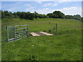
2
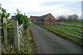
Approach to Alderminster Farm
The footpath goes this far from the main road towards the farm, then a footpath diversion takes it left around the north side of the buildings. Shakespeare's Way follows this route.
Image: © Graham Horn
Taken: 12 Jan 2013
0.06 miles
3
Towards Alderminster Farm
The public footpath, used by Shakespeare's Way, follows a route above the flood plain of the River Stour, off to the left. It used to go between the farm buildings, but now heads round them to the right.
Image: © Graham Horn
Taken: 12 Jan 2013
0.06 miles
4
Track to Alderminster Farm
This track runs south from the A3400 to the farm which can be seen in the distance and which actually lies in SP2149.
Image: © Nigel Mykura
Taken: 2 Sep 2012
0.12 miles
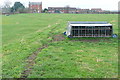
5
Entrance to Alderminster Farm from A3400
Looking WSW down the entrance drive towards Alderminster Farm in Image
Image: © David P Howard
Taken: 27 Mar 2010
0.16 miles
6
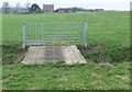
Towards Alderminster Farm
The footpath, used by Shakespeare's Way, crosses a tributary of the River Stour on this bridge, then follows the higher ground towards the right of the farm buildings. The gate is a simple one to stop stock straying, until humans create too much of a path either side which the stock will be able to follow. Is it that difficult to open the smaller gate?
Image: © Graham Horn
Taken: 12 Jan 2013
0.18 miles
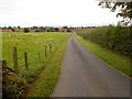
7
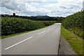
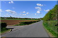
Wimpstone Lane
Wimpstone Lane with Meon Hill visible in the distance.
Image: © Philip Halling
Taken: 17 Jul 2023
0.21 miles
8
Shakespeare's Way
Shakespeare's Way heading to Alderminster
Image: © Shaun Ferguson
Taken: 13 Jun 2014
0.23 miles
9
Wimpstone Lane
Entrance to Alderminster Farm on the left
Image: © Tim Heaton
Taken: 27 Apr 2015
0.23 miles