IMAGES TAKEN NEAR TO
Pebworth, STRATFORD-UPON-AVON, CV37 8AN
Introduction
This page details the photographs taken nearby to CV37 8AN by members of the Geograph project.
The Geograph project started in 2005 with the aim of publishing, organising and preserving representative images for every square kilometre of Great Britain, Ireland and the Isle of Man.

There are currently over 7.5m images from over14,400 individuals and you can help contribute to the project by visiting https://www.geograph.org.uk
Image Map
Images are licensed for reuse under creativecommons.org/licenses/by-sa/2.0
Notes
- Clicking on the map will re-center to the selected point.
- The higher the marker number, the further away the image location is from the centre of the postcode.
Image Listing (3 Images Found)
Images are licensed for reuse under creativecommons.org/licenses/by-sa/2.0
Image
Details
Distance
1
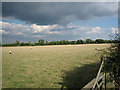
Pebworth Pasture
Looking north-east across pasture land from the Long Marston to Dorsington road.
Image: © Dave Bushell
Taken: 20 Sep 2005
0.17 miles
2
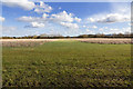
New plantation alongside Long Marston Road
View ESE from Long Marston Road over what appears to be a fairly newly planted tree plantation.
Image: © David P Howard
Taken: 17 Feb 2015
0.22 miles
3
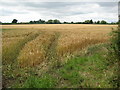
Wheat field near Pebworth
This wheat field is just within the county of Worcestershire.
Image: © Philip Halling
Taken: 24 Jul 2010
0.23 miles