IMAGES TAKEN NEAR TO
Long Marston Road, STRATFORD-UPON-AVON, CV37 8AE
Introduction
This page details the photographs taken nearby to Long Marston Road, CV37 8AE by members of the Geograph project.
The Geograph project started in 2005 with the aim of publishing, organising and preserving representative images for every square kilometre of Great Britain, Ireland and the Isle of Man.

There are currently over 7.5m images from over14,400 individuals and you can help contribute to the project by visiting https://www.geograph.org.uk
Image Map (Loading...)


Getting Data...Please wait
Leaflet Map data © OpenStreetMap
Images are licensed for reuse under creativecommons.org/licenses/by-sa/2.0
Notes
- Clicking on the map will re-center to the selected point.
- The higher the marker number, the further away the image location is from the centre of the postcode.
Image Listing (2 Images Found)
Images are licensed for reuse under creativecommons.org/licenses/by-sa/2.0
Image
Details
Distance
1

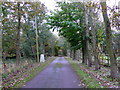
Approach to Welford Hill Farm
This tarmac approach road comes off the Long Marston Rd in SP1550 and runs west along the ridge of Welford Hill and then turns sharp south to the farm itself. This is not a working farm and there appear to be several large private residences on the site.
Image: © Nigel Mykura
Taken: 28 Oct 2012
0.04 miles
2
Trig Point of Welford Hill
This trig point is on a private road leading up to a group of private dwellings at Welford Hill Farm.
Image: © Nigel Mykura
Taken: 28 Oct 2012
0.07 miles