IMAGES TAKEN NEAR TO
Church Close, STRATFORD-UPON-AVON, CV37 7QG
Introduction
This page details the photographs taken nearby to Church Close, CV37 7QG by members of the Geograph project.
The Geograph project started in 2005 with the aim of publishing, organising and preserving representative images for every square kilometre of Great Britain, Ireland and the Isle of Man.

There are currently over 7.5m images from over14,400 individuals and you can help contribute to the project by visiting https://www.geograph.org.uk
Image Map
Images are licensed for reuse under creativecommons.org/licenses/by-sa/2.0
Notes
- Clicking on the map will re-center to the selected point.
- The higher the marker number, the further away the image location is from the centre of the postcode.
Image Listing (43 Images Found)
Images are licensed for reuse under creativecommons.org/licenses/by-sa/2.0
Image
Details
Distance
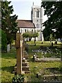
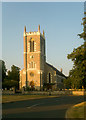
1
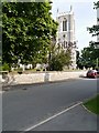
The Church of St James, Alveston
This church was developed during the Victorian era when the Old Church, on Mill Lane (Image]), became too cramped for its growing and more prosperous, congregation (http://www.divine-inspiration.org.uk/churches/fosse/st-james-alveston Divine Inspiration).
The church, opened in 1939 and extended in 1876, is a Grade II Listed Building (English Heritage ID:366185 http://www.britishlistedbuildings.co.uk/en-366185-church-of-st-james-stratford-upon-avon-w British Listed Buildings).
Image: © David Dixon
Taken: 5 Jul 2013
0.05 miles
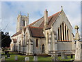
2
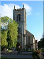
Church of St James, Alveston
The west end of the church. For more information see http://www.achurchnearyou.com/alveston-st-james/
Image: © David P Howard
Taken: 11 Oct 2010
0.06 miles
4
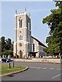
Alveston, St James' Church
This church was developed during the Victorian era when the Old Church, on Mill Lane (Image]), became too cramped for its growing and more prosperous, congregation (http://www.divine-inspiration.org.uk/churches/fosse/st-james-alveston Divine Inspiration).
The church, opened in 1939 and extended in 1876, is a Grade II Listed Building (English Heritage ID:366185 http://www.britishlistedbuildings.co.uk/en-366185-church-of-st-james-stratford-upon-avon-w British Listed Buildings).
Image: © David Dixon
Taken: 5 Jul 2013
0.06 miles
5
Alveston, St James' Church
This church was developed during the Victorian era when the Old Church, on Mill Lane (Image]), became too cramped for its growing and more prosperous, congregation (http://www.divine-inspiration.org.uk/churches/fosse/st-james-alveston Divine Inspiration).
The church, opened in 1939 and extended in 1876, is a Grade II Listed Building (English Heritage ID:366185 http://www.britishlistedbuildings.co.uk/en-366185-church-of-st-james-stratford-upon-avon-w British Listed Buildings).
Image: © David Dixon
Taken: 5 Jul 2013
0.06 miles
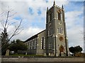
7
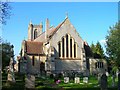
Church of St James, Alveston
The east end of the church on a sunny autumn day. For more information see http://www.achurchnearyou.com/alveston-st-james/
Image: © David P Howard
Taken: 11 Oct 2010
0.08 miles
9
St James's Church, Alveston (1839)
Grade II listed building, described at this http://list.english-heritage.org.uk/resultsingle.aspx?uid=1204420. Architect William Walker.
Image: © Jim Osley
Taken: 18 Jul 2013
0.08 miles
10
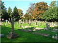
Churchyard, St James, Alveston
Looking WNW across the churchyard towards the corner which is at the junction of Kissing Tree Way on the right, and Church Lane on the left.
Image: © David P Howard
Taken: 11 Oct 2010
0.08 miles