IMAGES TAKEN NEAR TO
Halford Road, STRATFORD-UPON-AVON, CV37 7PJ
Introduction
This page details the photographs taken nearby to Halford Road, CV37 7PJ by members of the Geograph project.
The Geograph project started in 2005 with the aim of publishing, organising and preserving representative images for every square kilometre of Great Britain, Ireland and the Isle of Man.

There are currently over 7.5m images from over14,400 individuals and you can help contribute to the project by visiting https://www.geograph.org.uk
Image Map (Loading...)


Getting Data...Please wait
Leaflet Map data © OpenStreetMap
Images are licensed for reuse under creativecommons.org/licenses/by-sa/2.0
Notes
- Clicking on the map will re-center to the selected point.
- The higher the marker number, the further away the image location is from the centre of the postcode.
Image Listing (7 Images Found)
Images are licensed for reuse under creativecommons.org/licenses/by-sa/2.0
Image
Details
Distance
1
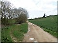
Driveway to the farm
From the A429 road, this driveway leads to Lambcote Farm.
Image: © Michael Dibb
Taken: 30 Mar 2017
0.19 miles
2
Farm drive
Following the stream near the northern edge of the square.
Image: © David Stowell
Taken: 2 Jun 2006
0.20 miles
3
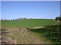
View south from entrance to Lambcote Farm
Looking south from the entrance to the farm. The A429 is just out of shot on the right.
This photo was taken during the no-fly period (15/4/10 – 20/4/10) caused by the eruption of the 1666 metre Icelandic volcano, Mount Eyjafjallajökull. There is no trace of vapour trails across this perfect clear sky.
Image: © David P Howard
Taken: 17 Apr 2010
0.21 miles
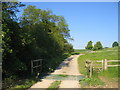
4
Drive to Lambcote Farm
Drive to Lambcote Farm off the A429.
Image: © Philip Halling
Taken: 9 Mar 2017
0.21 miles
5

Stream by footpath to Ettington
A small stream that the footpath crosses shortly after leaving the A429
Image: © David P Howard
Taken: 17 Apr 2010
0.22 miles
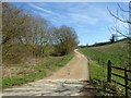
6

Entrance drive to Lambcote Farm, from A429
Looking east up the entrance drive. The farm is about half a kilometre away, and that is a long way to put your wheelie bins out each week.
This photo was taken during the no-fly period (15/4/10 – 20/4/10) caused by the eruption of the 1666 metre Icelandic volcano, Mount Eyjafjallajökull. There is no trace of vapour trails across this perfect clear sky.
Image: © David P Howard
Taken: 17 Apr 2010
0.23 miles
7
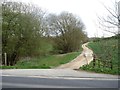
Path leaves the road
From the A429 near the junction with the road to Halford, a footpath runs to Ettington. The path runs through the gap in the trees and not along the drive which leads to Lambcote Farm.
Image: © Michael Dibb
Taken: 30 Mar 2017
0.24 miles