IMAGES TAKEN NEAR TO
Goldicote Business Park, Banbury Road, STRATFORD-UPON-AVON, CV37 7NB
Introduction
This page details the photographs taken nearby to Goldicote Business Park, Banbury Road, CV37 7NB by members of the Geograph project.
The Geograph project started in 2005 with the aim of publishing, organising and preserving representative images for every square kilometre of Great Britain, Ireland and the Isle of Man.

There are currently over 7.5m images from over14,400 individuals and you can help contribute to the project by visiting https://www.geograph.org.uk
Image Map (Loading...)


Getting Data...Please wait
Leaflet Map data © OpenStreetMap
Images are licensed for reuse under creativecommons.org/licenses/by-sa/2.0
Notes
- Clicking on the map will re-center to the selected point.
- The higher the marker number, the further away the image location is from the centre of the postcode.
Image Listing (30 Images Found)
Images are licensed for reuse under creativecommons.org/licenses/by-sa/2.0
Image
Details
Distance
1
![Goldicote Business Park [1]](https://s1.geograph.org.uk/geophotos/02/84/73/2847337_a0046a33_120x120.jpg)
Goldicote Business Park [1]
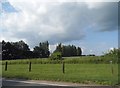
The park is seen, across the field, from the A422 road.
Image: © Michael Dibb
Taken: 22 Jan 2012
0.06 miles
2
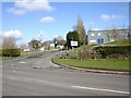
Entrance to Goldicote Business Park
Entrance to the business park off the A422 Banbury Road.
Image: © David P Howard
Taken: 20 Feb 2010
0.11 miles
4
![Goldicote Business Park [2]](https://s0.geograph.org.uk/geophotos/02/84/73/2847344_ae9804a4_120x120.jpg)
Goldicote Business Park [2]
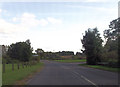
The entrance to the park from the A422 road.
Image: © Michael Dibb
Taken: 22 Jan 2012
0.11 miles
6
![Once were trains [2]](https://s1.geograph.org.uk/geophotos/02/84/73/2847377_720116e0_120x120.jpg)
Once were trains [2]
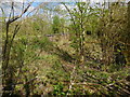
A view from the bridge that once carried the A422 road along the trackbed of the long dismantled Stratford and Midland Junction Railway, looking in the direction of Ettington. There is a great amount of detail and a large number of photographs about of the former railway at: http://warwickshirerailways.com/lms/stratfordmidland.htm
Image: © Michael Dibb
Taken: 22 Jan 2012
0.15 miles
7
![Once were trains [1]](https://s1.geograph.org.uk/geophotos/02/84/73/2847309_34be643b_120x120.jpg)
Once were trains [1]
Incorrectly described as a disused pit on the OS 1:25,000 map, this is part of the cutting used by the Stratford and Midland Junction Railway. Part of the cutting has been filled in and the A422 road has been realigned.
Image: © Michael Dibb
Taken: 22 Jan 2012
0.15 miles
8
![Once was traffic [2]](https://s3.geograph.org.uk/geophotos/02/84/73/2847367_29c09984_120x120.jpg)
Once was traffic [2]
This bridge once carried the A422 road over the Stratford and Midland Junction Railway. The route of the A422 was along what is now the minor road to Alderminster before it made a 90 degree turn to the right to cross the railway then it made another 90 degree turn, this time to the left. Part of the railway cutting has been filled in and the road realigned.
Image: © Michael Dibb
Taken: 22 Jan 2012
0.16 miles
9
![Once was traffic [1]](https://s2.geograph.org.uk/geophotos/02/84/73/2847362_a623bfd8_120x120.jpg)
Once was traffic [1]
Seen from the A422, is the bridge which once carried the road over the Stratford and Midland Junction Railway. The route of the A422 was along what is now the minor road to Alderminster before it made a 90 degree turn to the right to cross the railway then it made another 90 degree turn, this time to the left. Part of the railway cutting has been filled in and the road realigned.
Image: © Michael Dibb
Taken: 22 Jan 2012
0.16 miles
10
Shennington-Abandoned Road Bridge
The road originally crossed the dismantled Stratford and Midland Junction Railway at this point, before being re directed.
Image: © Ian Rob
Taken: 22 Apr 2017
0.16 miles