IMAGES TAKEN NEAR TO
Amis Way, STRATFORD-UPON-AVON, CV37 7JD
Introduction
This page details the photographs taken nearby to Amis Way, CV37 7JD by members of the Geograph project.
The Geograph project started in 2005 with the aim of publishing, organising and preserving representative images for every square kilometre of Great Britain, Ireland and the Isle of Man.

There are currently over 7.5m images from over14,400 individuals and you can help contribute to the project by visiting https://www.geograph.org.uk
Image Map (Loading...)


Getting Data...Please wait
Leaflet Map data © OpenStreetMap
Images are licensed for reuse under creativecommons.org/licenses/by-sa/2.0
Notes
- Clicking on the map will re-center to the selected point.
- The higher the marker number, the further away the image location is from the centre of the postcode.
Image Listing (5 Images Found)
Images are licensed for reuse under creativecommons.org/licenses/by-sa/2.0
Image
Details
Distance
1
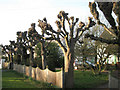
Pollarded limes, Banbury Road
In a small space this style of pollarding, rather than crude lopping, is an attractive way of managing limes (Tilia spp.), otherwise they grow alarmingly tall.
Image: © Robin Stott
Taken: 6 Mar 2011
0.11 miles
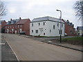
2
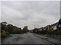
Dale Avenue
Dale Avenue passing Eton Road and Avon Crescent
Image: © Shaun Ferguson
Taken: 23 Apr 2021
0.15 miles
3
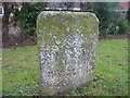
Milestone on the Banbury Road
This is the milestone shown on the OS map near the northern edge of this square. The sign is barely legible and seems to indicate 1 mile to Stratford and 10 miles to Shipston.
Image: © David Stowell
Taken: 5 Feb 2006
0.19 miles
4
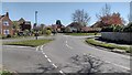
Long Fellow Road, Bridgetown
Looking SW into the new housing estate development on the site of Bridgetown Farm.
Image: © David Stowell
Taken: 5 Feb 2006
0.20 miles