IMAGES TAKEN NEAR TO
Moles End, STRATFORD-UPON-AVON, CV37 7FP
Introduction
This page details the photographs taken nearby to Moles End, CV37 7FP by members of the Geograph project.
The Geograph project started in 2005 with the aim of publishing, organising and preserving representative images for every square kilometre of Great Britain, Ireland and the Isle of Man.

There are currently over 7.5m images from over14,400 individuals and you can help contribute to the project by visiting https://www.geograph.org.uk
Image Map
Images are licensed for reuse under creativecommons.org/licenses/by-sa/2.0
Notes
- Clicking on the map will re-center to the selected point.
- The higher the marker number, the further away the image location is from the centre of the postcode.
Image Listing (16 Images Found)
Images are licensed for reuse under creativecommons.org/licenses/by-sa/2.0
Image
Details
Distance
1
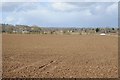
Farmland at Stratford-upon-Avon
Farmland east of Stratford-upon-Avon and to the north of Loxley Road. On the horizon to the left is the obelisk in the parkland at the Welcombe Hotel.
Image: © Philip Halling
Taken: 16 Mar 2018
0.03 miles
2
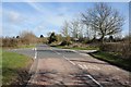
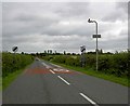
Crossroads on Loxley Road
Crossroads of Loxley Road and Knight's Road to the east of Stratford-upon-Avon.
Image: © Philip Halling
Taken: 16 Mar 2018
0.07 miles
3
Junction of Loxley Road and Knights Lane
View North up Knights Lane to the junction with Loxley Road.
Image: © David P Howard
Taken: 3 Feb 2010
0.07 miles
4
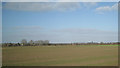
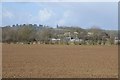
The wide flat Avon valley
The view from Loxley Road towards Alveston, with the south side of Tiddington on the left and Knights Lane crossing the picture.
Image: © Robin Stott
Taken: 6 Mar 2011
0.09 miles
5
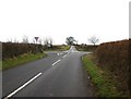
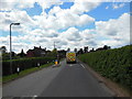
Loxley Road
Leaving Stratford Upon Avon.
Image: © Steve Fareham
Taken: 22 Jul 2008
0.09 miles
6
Farmland at Stratford-upon-Avon
View across farmland, to the east of Stratford-upon-Avon, towards the obelisk in the parkland of the Welcombe Hotel.
Image: © Philip Halling
Taken: 16 Mar 2018
0.10 miles
7
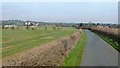
Knight's Lane
Looking towards Tiddington. Sports Ground visible in left mid-distance.
Image: © Clint Mann
Taken: 26 Feb 2016
0.10 miles
8
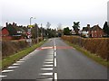
Traffic calming on Loxley Road
Compare this shot with Image The yellow teeth are now white, the 30 limit is 100 metres further out, there are four new street lights, and a traffic calming chicane has appeared. In addition there are road humps for the next 1500 metres all the way into Stratford.
Image: © David P Howard
Taken: 3 Feb 2010
0.13 miles
10

View from Alveston Hill
Looking NW with the buildings of Arden Heath Farm just across the field. In the distance some of the rooftops of Stratford-upon-Avon can be seen amongst the trees.
Image: © David Stowell
Taken: 13 Dec 2005
0.17 miles