IMAGES TAKEN NEAR TO
Blackberry Lane, STRATFORD-UPON-AVON, CV37 7FH
Introduction
This page details the photographs taken nearby to Blackberry Lane, CV37 7FH by members of the Geograph project.
The Geograph project started in 2005 with the aim of publishing, organising and preserving representative images for every square kilometre of Great Britain, Ireland and the Isle of Man.

There are currently over 7.5m images from over14,400 individuals and you can help contribute to the project by visiting https://www.geograph.org.uk
Image Map
Images are licensed for reuse under creativecommons.org/licenses/by-sa/2.0
Notes
- Clicking on the map will re-center to the selected point.
- The higher the marker number, the further away the image location is from the centre of the postcode.
Image Listing (15 Images Found)
Images are licensed for reuse under creativecommons.org/licenses/by-sa/2.0
Image
Details
Distance
1
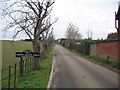
The last houses in Loxley Road
Beyond this are farm fields. Loxley Road could be called ribbon development. The road is lined with houses for 1.4km east of the Tiddington Road.
Image: © Robin Stott
Taken: 6 Mar 2011
0.03 miles
2
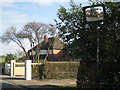
Arden Heath Farm
The entrance to the farm, itself just visible in the distance, from Loxley Road.
Image: © David Stowell
Taken: 13 Dec 2005
0.04 miles
3

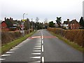
Road with teeth
Approaching the edge of Stratford-upon-Avon on the Loxley Road.
Image: © David Stowell
Taken: 13 Dec 2005
0.04 miles
4
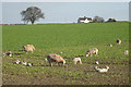
Ewes, lambs and turnips
On Arden Heath Farm, seen from the Loxley Road. On the skyline, up Alveston Hill, is a house and another structure at the junction of Knights Lane and Pimlico Lane.
Image: © Robin Stott
Taken: 6 Mar 2011
0.04 miles
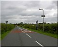
6
Traffic calming on Loxley Road
Compare this shot with Image The yellow teeth are now white, the 30 limit is 100 metres further out, there are four new street lights, and a traffic calming chicane has appeared. In addition there are road humps for the next 1500 metres all the way into Stratford.
Image: © David P Howard
Taken: 3 Feb 2010
0.08 miles
7
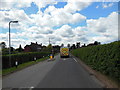
Loxley Road
Leaving Stratford Upon Avon.
Image: © Steve Fareham
Taken: 22 Jul 2008
0.12 miles
8
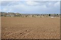
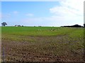
Farmland at Stratford-upon-Avon
Farmland east of Stratford-upon-Avon and to the north of Loxley Road. On the horizon to the left is the obelisk in the parkland at the Welcombe Hotel.
Image: © Philip Halling
Taken: 16 Mar 2018
0.18 miles
9
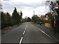
Loxley Road, Stratford-upon-Avon
View East along the Loxley Road.
Image: © David P Howard
Taken: 27 Feb 2010
0.19 miles
10
Arden Heath Farm
Arden Heath Farm are the buildings on the right. Viewed from the minor road running east out of Stratford to Loxley. The white house on the left is at Alveston Hill.
Image: © Nigel Mykura
Taken: 6 Mar 2011
0.19 miles