IMAGES TAKEN NEAR TO
Loxley Road, STRATFORD-UPON-AVON, CV37 7DT
Introduction
This page details the photographs taken nearby to Loxley Road, CV37 7DT by members of the Geograph project.
The Geograph project started in 2005 with the aim of publishing, organising and preserving representative images for every square kilometre of Great Britain, Ireland and the Isle of Man.

There are currently over 7.5m images from over14,400 individuals and you can help contribute to the project by visiting https://www.geograph.org.uk
Image Map
Images are licensed for reuse under creativecommons.org/licenses/by-sa/2.0
Notes
- Clicking on the map will re-center to the selected point.
- The higher the marker number, the further away the image location is from the centre of the postcode.
Image Listing (5 Images Found)
Images are licensed for reuse under creativecommons.org/licenses/by-sa/2.0
Image
Details
Distance
1
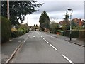
Loxley Road, Stratford-upon-Avon
View West along the Loxley Road. Note the traffic calming humps which run the whole length of the road.
Image: © David P Howard
Taken: 27 Feb 2010
0.01 miles
2
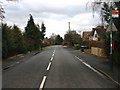
Loxley Road, Stratford-upon-Avon
View East along the Loxley Road.
Image: © David P Howard
Taken: 27 Feb 2010
0.05 miles
3
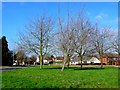
Patch of Green
This small triangle of land with a few trees on it is at the junction of Avon Crescent and Dale Avenue just south of the Loxley Rd.
Image: © Nigel Mykura
Taken: 6 Mar 2011
0.11 miles
4
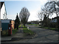
North end of Avon Crescent
Seen from Loxley Road. Postbox number CV37 75.
Image: © Robin Stott
Taken: 6 Mar 2011
0.12 miles
5
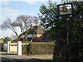
The last houses in Loxley Road
Beyond this are farm fields. Loxley Road could be called ribbon development. The road is lined with houses for 1.4km east of the Tiddington Road.
Image: © Robin Stott
Taken: 6 Mar 2011
0.20 miles