IMAGES TAKEN NEAR TO
Maidenhead Road, STRATFORD-UPON-AVON, CV37 6XS
Introduction
This page details the photographs taken nearby to Maidenhead Road, CV37 6XS by members of the Geograph project.
The Geograph project started in 2005 with the aim of publishing, organising and preserving representative images for every square kilometre of Great Britain, Ireland and the Isle of Man.

There are currently over 7.5m images from over14,400 individuals and you can help contribute to the project by visiting https://www.geograph.org.uk
Image Map (Loading...)


Getting Data...Please wait
Leaflet Map data © OpenStreetMap
Images are licensed for reuse under creativecommons.org/licenses/by-sa/2.0
Notes
- Clicking on the map will re-center to the selected point.
- The higher the marker number, the further away the image location is from the centre of the postcode.
Image Listing (229 Images Found)
Images are licensed for reuse under creativecommons.org/licenses/by-sa/2.0
Image
Details
Distance
1
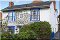
Attractive cottage
Pretty cottage in Stratford upon Avon with the date 1812 on its side wall.
Image: © Colin Craig
Taken: 15 Mar 2009
0.00 miles
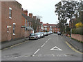
2
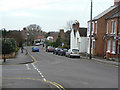
Maidenhead Road
Residential area to the north of the town centre. Looking south at St Gregory's Road.
Image: © Alan Murray-Rust
Taken: 6 Mar 2011
0.01 miles
3
St Gregory's Road
Looking up St. Gregory's Road towards the junction with Maidenhead Road.
Image: © David P Howard
Taken: 21 Apr 2011
0.02 miles
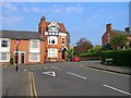
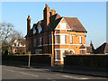
4
Houses on the corner of St Gregory's Road
Early 20th Century pseudo half-timbering.
Image: © Alan Murray-Rust
Taken: 6 Mar 2011
0.02 miles
5
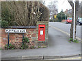
Maidenhead Road postbox ref.CV37 28
G VI R wallbox on the corner of Mayfield Avenue.
Image: © Alan Murray-Rust
Taken: 6 Mar 2011
0.03 miles
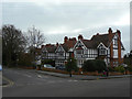
6
Mayfield Avenue
Early 20th century development to the north of the town centre.
Image: © Alan Murray-Rust
Taken: 6 Mar 2011
0.05 miles
7
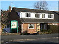
Stratford Quaker Meeting House
This was a private house, where for many years Quakers had held their Meetings for Worship, generously gifted by the owner to become a proper Meeting House.
Image: © Alan Murray-Rust
Taken: 6 Mar 2011
0.06 miles
8
House on Rowley Crescent
Older maps show that this was one of the older houses to be developed in this area, by about 1890.
Image: © Alan Murray-Rust
Taken: 6 Mar 2011
0.07 miles
9
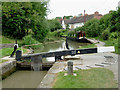
Maidenhead Road Lock in Stratford-upon-Avon, Warwickshire
This is Lock no 53 on the Stratford-upon-Avon Canal. Both ground paddles are up and water has almost filled the lock chamber. The moored boat will pass through on its way to the basin in Stratford centre. The housing is in Kendall Avenue.
There is a flight of four locks down through Stratford-upon-Avon, then a fifth into the River Avon. This is the second from the top, raising the water level by 6ft 10in (just over two metres).
See Image]
Image: © Roger D Kidd
Taken: 24 Aug 2012
0.08 miles
10
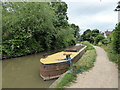
Narrowboat on Stratford-upon-Avon Canal
Image: © PAUL FARMER
Taken: 12 Jun 2018
0.08 miles