IMAGES TAKEN NEAR TO
Tyler Street, STRATFORD-UPON-AVON, CV37 6TY
Introduction
This page details the photographs taken nearby to Tyler Street, CV37 6TY by members of the Geograph project.
The Geograph project started in 2005 with the aim of publishing, organising and preserving representative images for every square kilometre of Great Britain, Ireland and the Isle of Man.

There are currently over 7.5m images from over14,400 individuals and you can help contribute to the project by visiting https://www.geograph.org.uk
Image Map (Loading...)


Getting Data...Please wait
Leaflet Map data © OpenStreetMap
Images are licensed for reuse under creativecommons.org/licenses/by-sa/2.0
Notes
- Clicking on the map will re-center to the selected point.
- The higher the marker number, the further away the image location is from the centre of the postcode.
Image Listing (1129 Images Found)
Images are licensed for reuse under creativecommons.org/licenses/by-sa/2.0
Image
Details
Distance
1
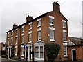
Period housing
An attractive period block in Stratford upon Avon.
Image: © Colin Craig
Taken: 7 Feb 2009
0.02 miles
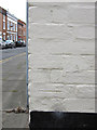
2
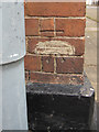
Altered bench mark on #1 Payton Street
This unusual bench mark has had the original datum line filled in with some sort of 'paste', and a new datum line has been cut higher up without an arrowhead. See also Image]
Image: © John S Turner
Taken: 1 Aug 2011
0.02 miles
3
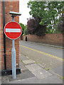
The corner of Lock Close and Payton Street
Looking across Payton Street at its junction with Lock Close. There is an altered bench mark behind the 'no entry' signpost - Image
Image: © John S Turner
Taken: 1 Aug 2011
0.02 miles
4
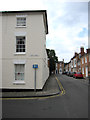
The corner of John Street and Payton Street
Looking along Payton Street at its junction with John Street. There is a bench mark on the Payton Street face of the white-painted building - Image
Image: © John S Turner
Taken: 1 Aug 2011
0.03 miles
5
Damaged bench mark on #6 John Street
This bench mark is actually on the Payton Street face of #6 John Street. See also Image]
Image: © John S Turner
Taken: 1 Aug 2011
0.03 miles
6

John Street, Stratford-upon-Avon
Viewed from Guild Street looking towards Payton Street.
John Street is part of the early nineteenth century development known as New Town.
Image: © Jaggery
Taken: 7 Jul 2012
0.04 miles
7
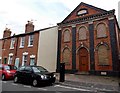
Masonic Hall, Great William Street, Stratford-upon-Avon
The building was formerly a chapel, a place of worship for Primitive Methodists. The date on the foundation stone is March 30th 1866. In 1932, the Wesleyan Methodist churches officially united with the Primitive Methodists. In Stratford the two churches continued to operate separately until Easter 1939, when the two congregations were united and this chapel was sold to the Masons.
Image: © Jaggery
Taken: 24 Aug 2014
0.05 miles
8
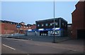
Fountain drive in dry cleaners on Guild Street, Stratford-upon-Avon
Image: © David Howard
Taken: 30 May 2020
0.05 miles
9
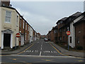
Great William Street
Looking north from Guild Street. Most of the streets on the north side of Guild Street are one way to minimise hold-ups of through traffic resulting from vehicles waiting to turn into the side streets.
Image: © Alan Murray-Rust
Taken: 6 Mar 2011
0.05 miles
10
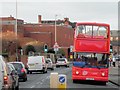
Tourist Bus on Guild Street
Former London Stagecoach 17417 (LX 51 FJE) on Guild Street. 17317, a Dennis Trident/Alexander ALX400 double decker, has been converted to open top layout and is now operating the Stratford-Upon-Avon tours service.
Image: © David Dixon
Taken: 9 Dec 2013
0.05 miles