IMAGES TAKEN NEAR TO
Wellesbourne Grove, STRATFORD-UPON-AVON, CV37 6PD
Introduction
This page details the photographs taken nearby to Wellesbourne Grove, CV37 6PD by members of the Geograph project.
The Geograph project started in 2005 with the aim of publishing, organising and preserving representative images for every square kilometre of Great Britain, Ireland and the Isle of Man.

There are currently over 7.5m images from over14,400 individuals and you can help contribute to the project by visiting https://www.geograph.org.uk
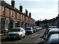
Image Map
Images are licensed for reuse under creativecommons.org/licenses/by-sa/2.0
Notes
- Clicking on the map will re-center to the selected point.
- The higher the marker number, the further away the image location is from the centre of the postcode.
Image Listing (720 Images Found)
Images are licensed for reuse under creativecommons.org/licenses/by-sa/2.0
Image
Details
Distance
1
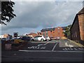
Car park on Grove Road, Stratford on Avon
Image: © David Howard
Taken: 3 Jun 2018
0.03 miles
2
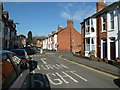
Albany Road, Stratford on Avon
The junction with Wellesbourne Road is seen to the right. Alcester Road crosses in the distance.
Image: © Chris Allen
Taken: 6 Mar 2011
0.04 miles
3
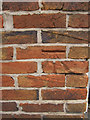
Bench mark on #1 Laburnum Cottages, Grove Road
This bench mark is on the south west corner of #1 Laburnum Cottages. The mark was recorded on the 1886 Town Plans levelled at 130.4 feet, and at that time the cottages were named Paradise Row. See also Image]
Image: © John S Turner
Taken: 1 Aug 2011
0.04 miles
4
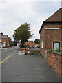
Grove Road and #1 Laburnum Cottages
Looking north along Grove Road with the end wall of #1 Laburnum Cottages on the right. There is a bench mark on the near corner of the cottage - Image
Image: © John S Turner
Taken: 1 Aug 2011
0.04 miles
5
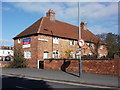
Laburnum Cottages, Grove Road, Stratford
A very pleasant simple terrace of 4 small houses - rather compromised by its setting by a busy road next to a car park and the modern police station.
Image: © John Brightley
Taken: 6 Mar 2011
0.04 miles
6
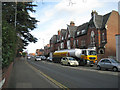
Arden Street
A heavily trafficked street, part of the principal route to the west of the town centre.
Image: © Robin Stott
Taken: 7 Feb 2011
0.05 miles
7
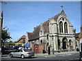
Stratford On Avon Church
The United Reformed Church in Rother Street.
Image: © Ian Rob
Taken: 1 Sep 2010
0.05 miles
8
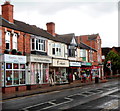
Shops at the western end of Greenhill Street, Stratford-upon-Avon
Looking towards the corner of Grove Road.
Image: © Jaggery
Taken: 7 Jul 2012
0.06 miles
9
Albany Road, stratford on Avon
An against the light shot.
Image: © Chris Allen
Taken: 6 Mar 2011
0.06 miles
10
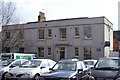
Fallen on hard times
This is Grove House in Greenhill Street, Stratford-upon-Avon. Although now forlorn, empty (up for rental) and marooned in a car park, it was originally a gentleman's residence built in 1826, with its own gardens and drive. Much altered over the years, most people pass it without a glance.
Image: © Colin Craig
Taken: 1 Mar 2009
0.07 miles