IMAGES TAKEN NEAR TO
Kings Lane, STRATFORD-UPON-AVON, CV37 0RB
Introduction
This page details the photographs taken nearby to Kings Lane, CV37 0RB by members of the Geograph project.
The Geograph project started in 2005 with the aim of publishing, organising and preserving representative images for every square kilometre of Great Britain, Ireland and the Isle of Man.

There are currently over 7.5m images from over14,400 individuals and you can help contribute to the project by visiting https://www.geograph.org.uk
Image Map (Loading...)


Getting Data...Please wait
Leaflet Map data © OpenStreetMap
Images are licensed for reuse under creativecommons.org/licenses/by-sa/2.0
Notes
- Clicking on the map will re-center to the selected point.
- The higher the marker number, the further away the image location is from the centre of the postcode.
Image Listing (11 Images Found)
Images are licensed for reuse under creativecommons.org/licenses/by-sa/2.0
Image
Details
Distance
1
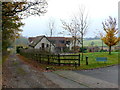
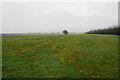
Little Acres Farm
As with many of the farms in this area this has been converted to a prestigious family residence. The track at the left side of the house is a bridle path that leads to Lower Welcombe Farm.
Image: © Nigel Mykura
Taken: 19 Nov 2011
0.01 miles
2
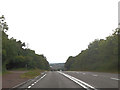
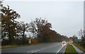
A46 at Oak Lodge
At start of the 3 lane carriageway
Image: © John Firth
Taken: 26 Sep 2012
0.07 miles
3
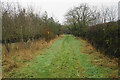
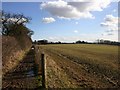
Footpath near Lower Clopton
The path is well marked by large yellow-topped posts.
Image: © Bill Boaden
Taken: 24 Dec 2021
0.13 miles
4
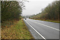
A46 above Lower Clopton
The road is currently in a cutting. On a clearer day, you would see some of the northern edge of Stratford-upon-Avon down the hill.
Image: © Bill Boaden
Taken: 24 Dec 2021
0.13 miles
6
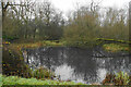
Pond near Lower Welcombe Farm
Viewed from the farm access track.
Image: © Bill Boaden
Taken: 24 Dec 2021
0.15 miles
7
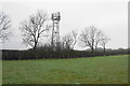
Mobile phone mast above Lower Clopton
On a rise above Stratford-upon-Avon but still fairly discreet.
Image: © Bill Boaden
Taken: 24 Dec 2021
0.18 miles
8
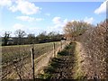
Bridleway to Lower Clopton
Looking West from the very edge of the gridsquare.
Image: © David P Howard
Taken: 1 Mar 2010
0.19 miles
9
A46 near Radcote Farm
Miserable winter driving conditions on the A46 just north of Stratford upon Avon in the extreme SW corner of the square
Image: © Nigel Mykura
Taken: 13 Nov 2008
0.19 miles
10
Bridleway to Welcombe Hills Country Park
View Southeast from the very edge of the gridsquare.
Image: © David P Howard
Taken: 1 Mar 2010
0.21 miles