IMAGES TAKEN NEAR TO
Stratford Northern Bypass, STRATFORD-UPON-AVON, CV37 0QD
Introduction
This page details the photographs taken nearby to Stratford Northern Bypass, CV37 0QD by members of the Geograph project.
The Geograph project started in 2005 with the aim of publishing, organising and preserving representative images for every square kilometre of Great Britain, Ireland and the Isle of Man.

There are currently over 7.5m images from over14,400 individuals and you can help contribute to the project by visiting https://www.geograph.org.uk
Image Map (Loading...)


Getting Data...Please wait
Leaflet Map data © OpenStreetMap
Images are licensed for reuse under creativecommons.org/licenses/by-sa/2.0
Notes
- Clicking on the map will re-center to the selected point.
- The higher the marker number, the further away the image location is from the centre of the postcode.
Image Listing (16 Images Found)
Images are licensed for reuse under creativecommons.org/licenses/by-sa/2.0
Image
Details
Distance
1
Track to Park Farm
Wet and dark November afternoon on the track that leads from the A46 south to Park Farm just south of the village of Snitterfield
Image: © Nigel Mykura
Taken: 13 Nov 2008
0.09 miles
2
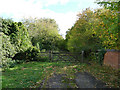
Footpath off Park Lane, Snitterfield
Image: © David P Howard
Taken: 13 Feb 2010
0.17 miles
3
Footpath crossing the A46 to Snitterfield
The south-east corner of Snitterfield is on the other side of this very busy road.
Image: © Tim Heaton
Taken: 25 Apr 2009
0.17 miles
4
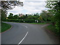
Junction of King's Lane and Park Lane, Snitterfield
With the start of Park Lane swinging off to the left. The gate to the right of the outside bend leads to a footpath which heads south-east across the A46.
Image: © Tim Heaton
Taken: 25 Apr 2009
0.18 miles
5
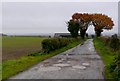
Traffic-free end of King's Lane
Beyond this gate King's Lane continues as a bridleway only.
Image: © Stephen Craven
Taken: 21 Sep 2018
0.19 miles
6
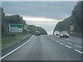
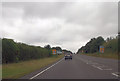
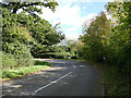
Snitterfield : The A46
Looking along the A46.
Image: © Lewis Clarke
Taken: 25 Sep 2021
0.19 miles
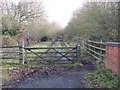
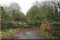
8
East end of King's Lane
The road bears to the left and becomes Park Lane, although King's Lane continues straight on as a bridleway.
Image: © Stephen Craven
Taken: 21 Sep 2018
0.19 miles
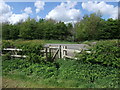
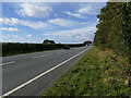
9
Former route of King's Lane
King's Lane was the main through route until superseded by the A46 which is behind the trees to the right. I presume the name reflects Charles II's route as he escaped after the Battle of Worcester.
Image: © Bill Boaden
Taken: 28 Dec 2021
0.19 miles