IMAGES TAKEN NEAR TO
Kings Lane, STRATFORD-UPON-AVON, CV37 0QB
Introduction
This page details the photographs taken nearby to Kings Lane, CV37 0QB by members of the Geograph project.
The Geograph project started in 2005 with the aim of publishing, organising and preserving representative images for every square kilometre of Great Britain, Ireland and the Isle of Man.

There are currently over 7.5m images from over14,400 individuals and you can help contribute to the project by visiting https://www.geograph.org.uk
Image Map (Loading...)


Getting Data...Please wait
Leaflet Map data © OpenStreetMap
Images are licensed for reuse under creativecommons.org/licenses/by-sa/2.0
Notes
- Clicking on the map will re-center to the selected point.
- The higher the marker number, the further away the image location is from the centre of the postcode.
Image Listing (16 Images Found)
Images are licensed for reuse under creativecommons.org/licenses/by-sa/2.0
Image
Details
Distance
1
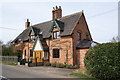
Country cottage
A Victorian cottage on the still-used part of the old King's Lane in Snitterfield. The cottage has been much extended on the side away from the camera.
Image: © Colin Craig
Taken: 16 Mar 2009
0.05 miles
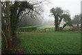
2
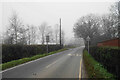
King's Lane
A misty view of the lane which was an important route before being superseded by the upgraded A46.
Image: © Bill Boaden
Taken: 24 Dec 2021
0.09 miles
4
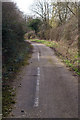
The white line fades
The remains of the former King's Lane near Snitterfield, much of which is now destroyed by the Stratford by-pass. This section is pretty much abandoned apart from dog walkers and horse riders. Enough remains to give a flavour of when this was a quiet country road.
Image: © Colin Craig
Taken: 16 Mar 2009
0.14 miles
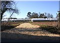
5
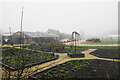
The Farm
A misty view of this farm shop which is on the Monarch's Way.
Image: © Bill Boaden
Taken: 24 Dec 2021
0.14 miles
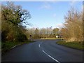
6

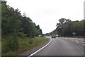
A46 approaching junctions near Snitterfield
First is a left junction to Snitterfield, followed by a right turn for Wilmcote and the Stratford Armouries.
Image: © J.Hannan-Briggs
Taken: 13 Oct 2016
0.14 miles
7
Road junction with Kings Lane near Hollow Meadow
Image: © John Firth
Taken: 26 Sep 2012
0.16 miles
8
Green Gates Caravan Park
Low occupancy in December and a very misty day.
Image: © Bill Boaden
Taken: 24 Dec 2021
0.18 miles
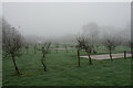
9
Footpath to Snitterfield
The path is segregated from the rest of the field by a cord which is not electrified.
Image: © Bill Boaden
Taken: 24 Dec 2021
0.18 miles
10
Polytunnels off Ingon Lane
On the west side of Ingon Lane a recently laid hardcore drive leads to a range of polytunnels.
Image: © David P Howard
Taken: 8 Mar 2010
0.19 miles