IMAGES TAKEN NEAR TO
Hatton Bank Lane, STRATFORD-UPON-AVON, CV37 0PB
Introduction
This page details the photographs taken nearby to Hatton Bank Lane, CV37 0PB by members of the Geograph project.
The Geograph project started in 2005 with the aim of publishing, organising and preserving representative images for every square kilometre of Great Britain, Ireland and the Isle of Man.

There are currently over 7.5m images from over14,400 individuals and you can help contribute to the project by visiting https://www.geograph.org.uk
Image Map
Images are licensed for reuse under creativecommons.org/licenses/by-sa/2.0
Notes
- Clicking on the map will re-center to the selected point.
- The higher the marker number, the further away the image location is from the centre of the postcode.
Image Listing (22 Images Found)
Images are licensed for reuse under creativecommons.org/licenses/by-sa/2.0
Image
Details
Distance
1
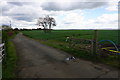
Farm lane off Hatton Bank Lane
Also used by a footpath, but the lane is not a public route for vehicles.
Image: © Bill Boaden
Taken: 29 Apr 2016
0.02 miles
2
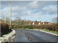
Cottages on Hatton Bank Lane Near Garden Centre
Image: © Roy Hughes
Taken: 29 Dec 2017
0.05 miles
3
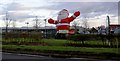
Ho ho ho....
Wyevale Garden Centre Santa.
Image: © Steve Fareham
Taken: 4 Dec 2008
0.08 miles
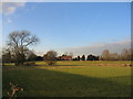
4
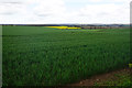
Wheat field by Hatton Bank Lane
Looking from the slightly higher ground on Black Hill down towards the Avon valley.
Image: © Bill Boaden
Taken: 29 Apr 2016
0.09 miles
5
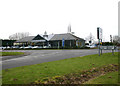
A439 Black Hill crossroads
Black Hill crossroads, with Mercedes-Benz, Stratford-upon-Avon on the West corner.
Image: © David P Howard
Taken: 13 Feb 2010
0.09 miles
6
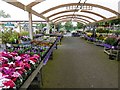
Flowers in the rain at Wyevale garden centre
Image: © Steve Fareham
Taken: 22 Sep 2015
0.09 miles
7
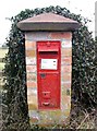
Victorian post box at Black Hill crossroads
Victorian postbox on the North side of Black Hill crossroads.
Image: © David P Howard
Taken: 13 Feb 2010
0.10 miles
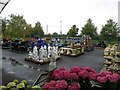
9
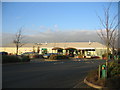
Garden Centre at Black Hill
Looking NE at the new garden centre at the SE corner of the crossroads at the top of Black Hill.
Image: © David Stowell
Taken: 10 Feb 2006
0.11 miles
10
High Close Farm
Looking north from the lane from Black Hill to Snitterfield with High Close Farm buildings visible in the trees.
Image: © David Stowell
Taken: 10 Feb 2006
0.11 miles