IMAGES TAKEN NEAR TO
Snitterfield, STRATFORD-UPON-AVON, CV37 0LR
Introduction
This page details the photographs taken nearby to CV37 0LR by members of the Geograph project.
The Geograph project started in 2005 with the aim of publishing, organising and preserving representative images for every square kilometre of Great Britain, Ireland and the Isle of Man.

There are currently over 7.5m images from over14,400 individuals and you can help contribute to the project by visiting https://www.geograph.org.uk
Image Map (Loading...)


Getting Data...Please wait
Leaflet Map data © OpenStreetMap
Images are licensed for reuse under creativecommons.org/licenses/by-sa/2.0
Notes
- Clicking on the map will re-center to the selected point.
- The higher the marker number, the further away the image location is from the centre of the postcode.
Image Listing (7 Images Found)
Images are licensed for reuse under creativecommons.org/licenses/by-sa/2.0
Image
Details
Distance
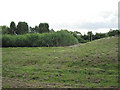
1
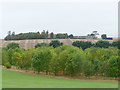
Lodge Farm
Viewed from near the top of Red Hill.
[Access Note: this photo was taken within the grounds of the Red Hill Centre while staying as a guest; apart from public rights of way the grounds are not public access].
Image: © Stephen Craven
Taken: 20 Sep 2018
0.02 miles
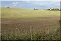
2
Concrete enclosure, Lodge Farm
The track up to the farm runs through a vast field of beans. The farm buildings are almost completely hidden from public view.
Image: © Robin Stott
Taken: 21 Jul 2010
0.03 miles
3
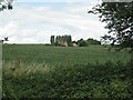
No.3 Lodge Farm
Access is from Snitterfield Lane, in this square, and from Lodge Farm Image
Image: © Robin Stott
Taken: 21 Jul 2010
0.18 miles
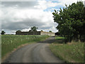
4
Luscombe House
Luscombe House is at a bend in a track behind the hedge on the left which leads west from the minor road leading into Snitterfield from the north east. At the end of the track is Lodge Farm in the next square west SP2160.
Image: © Nigel Mykura
Taken: 9 Jan 2011
0.18 miles
5
Reedbed, Snitterfield sewage works
Satellite photo shows four reedbeds; presumably they filter effluent before it flows to the Bell Brook: a 'green' technique.
Image: © Robin Stott
Taken: 21 Jul 2010
0.22 miles
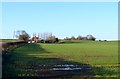
7
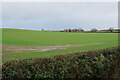
Green field near Snitterfield
An emerging crop is giving the smooth green effect. The building straight ahead is Luscombe House.
Image: © Bill Boaden
Taken: 28 Dec 2021
0.25 miles