IMAGES TAKEN NEAR TO
Barley Close, STRATFORD-UPON-AVON, CV37 0EH
Introduction
This page details the photographs taken nearby to Barley Close, CV37 0EH by members of the Geograph project.
The Geograph project started in 2005 with the aim of publishing, organising and preserving representative images for every square kilometre of Great Britain, Ireland and the Isle of Man.

There are currently over 7.5m images from over14,400 individuals and you can help contribute to the project by visiting https://www.geograph.org.uk
Image Map (Loading...)


Getting Data...Please wait
Leaflet Map data © OpenStreetMap
Images are licensed for reuse under creativecommons.org/licenses/by-sa/2.0
Notes
- Clicking on the map will re-center to the selected point.
- The higher the marker number, the further away the image location is from the centre of the postcode.
Image Listing (41 Images Found)
Images are licensed for reuse under creativecommons.org/licenses/by-sa/2.0
Image
Details
Distance
1
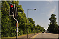
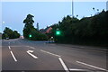
Stratford-Upon-Avon : Birmingham Road A3400
Waiting at the traffic lights on Birmingham Road.
Image: © Lewis Clarke
Taken: 1 Jul 2015
0.05 miles
3
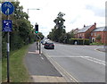
Crime Prevention Cameras in operation, Stratford-upon-Avon
The Warwickshire Police notice is alongside the A3400 Birmingham Road
in the Bishopton district of Stratford-upon-Avon. St Peters Way http://www.geograph.org.uk/photo/4140025 is on the right.
Image: © Jaggery
Taken: 24 Aug 2014
0.06 miles
4
Stratford-Upon-Avon : Town Sign
A sign welcoming visitors to Stratford-Upon-Avon.
Image: © Lewis Clarke
Taken: 1 Jul 2015
0.07 miles
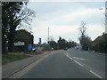
5
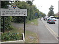
Welcome to Stratford-upon-Avon
The sign is alongside the A3400 Birmingham Road in the Bishopton district in the NW of Stratford.
No mention of The Bard on this sign - no doubt because most visitors know about William Shakespeare but few are likely to know about Stratford's Britain in Bloom success.
Image: © Jaggery
Taken: 24 Aug 2014
0.07 miles
6
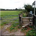
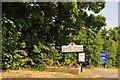
Public footpath from Stratford-upon-Avon to Snitterfield
The stile is at the edge of the A3400 Birmingham Road in Stratford-upon-Avon.
The sign on the right shows 3½ (miles) to Snitterfield.
Image: © Jaggery
Taken: 24 Aug 2014
0.08 miles
7
St Peters Way, Stratford-upon-Avon
In the Bishopton area of Stratford.
Image: © Jaggery
Taken: 24 Aug 2014
0.08 miles
8
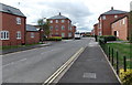
Birmingham Road, Stratford-upon-Avon
At the junction with St Peter's Way, a new road to a housing development.
Image: © David Howard
Taken: 30 May 2020
0.10 miles
9
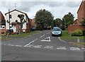
Rye Close, Stratford-upon-Avon
Viewed across Joseph Way.
Image: © Jaggery
Taken: 24 Aug 2014
0.11 miles
10
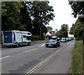
Cars cars cars, Stratford-upon-Avon
Viewed along the A3400 Birmingham Road from the boundary sign http://www.geograph.org.uk/photo/4140033 at the NW edge of Stratford.
The cars on the right are heading into Stratford in a slow-moving line of traffic about a mile long.
Image: © Jaggery
Taken: 24 Aug 2014
0.11 miles