IMAGES TAKEN NEAR TO
Maybrook Road, STRATFORD-UPON-AVON, CV37 0AB
Introduction
This page details the photographs taken nearby to Maybrook Road, CV37 0AB by members of the Geograph project.
The Geograph project started in 2005 with the aim of publishing, organising and preserving representative images for every square kilometre of Great Britain, Ireland and the Isle of Man.

There are currently over 7.5m images from over14,400 individuals and you can help contribute to the project by visiting https://www.geograph.org.uk
Image Map (Loading...)


Getting Data...Please wait
Leaflet Map data © OpenStreetMap
Images are licensed for reuse under creativecommons.org/licenses/by-sa/2.0
Notes
- Clicking on the map will re-center to the selected point.
- The higher the marker number, the further away the image location is from the centre of the postcode.
Image Listing (188 Images Found)
Images are licensed for reuse under creativecommons.org/licenses/by-sa/2.0
Image
Details
Distance
1
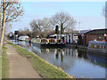
Valley Cruises
The Stratford base of the Nuneaton-based firm. All five boats appear to be at home, so business is clearly a bit slack at this time of year.
Image: © Alan Murray-Rust
Taken: 6 Mar 2011
0.03 miles
2

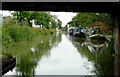
Stratford-upon-Avon Canal in Stratford
This is the view under Bridge No 64B, a disused railway bridge, west of One Elm Lock, No 52.
Image: © Roger D Kidd
Taken: 24 Aug 2012
0.03 miles
3
Stratford-upon-Avon Canal in Stratford
This is the view from under Bridge No 64B, a disused railway bridge, west of One Elm Lock, No 52.
Image: © Roger D Kidd
Taken: 24 Aug 2012
0.03 miles
4
The towpath, with moored canal barge, Stratford-upon-Avon Canal
The bridge in the distance is a disused railway bridge.
Image: © Ruth Sharville
Taken: 22 Aug 2022
0.04 miles
5
Moorings and boatyard in Stratford-upon-Avon, Warwickshire
These are private long term moorings. Ahead is the new Premier Inn by One Elm Lock, No 52.
Image: © Roger D Kidd
Taken: 24 Aug 2012
0.04 miles
6
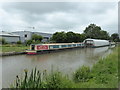
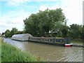
Narrowboat and floating workshop at Stratford-upon-Avon
Stratford-upon-Avon Canal.
A smart narrowboat is moored next to a floating polytunnel where boat maintenance and painting can be done.
Image: © Roger D Kidd
Taken: 24 Aug 2012
0.05 miles
7
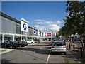
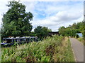
The Maybird Centre
A large shopping centre near the centre of Stratford-on-Avon on the Birmingham Road. Looking east. Much of the land developed in this area was released on the demise of the Flower's Brewery and the railway goods yards.
Image: © Dave Bushell
Taken: 27 Sep 2005
0.05 miles
8
Narrowboat 'Mary Mae' on Stratford-upon-Avon Canal
Image: © PAUL FARMER
Taken: 12 Jun 2018
0.05 miles
9
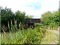
Disused railway bridge over the Stratford-upon-Avon Canal
Image: © Ruth Sharville
Taken: 22 Aug 2022
0.06 miles
10
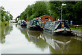
Floating polytunnel? on Stratford-upon-Avon Canal
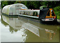
This strange vessel on the left looked like a floating polytunnel. In fact it is a wet dock, a place where a boat can be repaired or painted protected from the rain. Similar ones can be seen at Image and Image The inside of a similar structure can be seen at http://www.jim-shead.com/waterways/Articles.php?wpage=90. Thanks to John Brightley for the above information.
Image: © David P Howard
Taken: 16 Sep 2010
0.06 miles