IMAGES TAKEN NEAR TO
Great Wolford, SHIPSTON-ON-STOUR, CV36 5NT
Introduction
This page details the photographs taken nearby to CV36 5NT by members of the Geograph project.
The Geograph project started in 2005 with the aim of publishing, organising and preserving representative images for every square kilometre of Great Britain, Ireland and the Isle of Man.

There are currently over 7.5m images from over14,400 individuals and you can help contribute to the project by visiting https://www.geograph.org.uk
Image Map
Images are licensed for reuse under creativecommons.org/licenses/by-sa/2.0
Notes
- Clicking on the map will re-center to the selected point.
- The higher the marker number, the further away the image location is from the centre of the postcode.
Image Listing (3 Images Found)
Images are licensed for reuse under creativecommons.org/licenses/by-sa/2.0
Image
Details
Distance
1
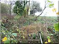
Across the brook
The path goes from Great Wolford to the Fire Service College at Moreton-in-Marsh. Here, the path crosses a brook and ascends a bank towards the open fields above. The brook is the county boundary - Warwickshire this side, Gloucestershire the far side.
Image: © Michael Dibb
Taken: 9 Nov 2009
0.13 miles
2
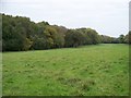
Long field, looking northeast
Leaving Botany Coppice, the path passes through a long, narrow field. This is the view looking northeast. Leamington Coppice is to the left.
Image: © Michael Dibb
Taken: 19 Oct 2009
0.16 miles
3
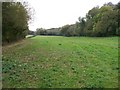
Long field, looking southwest
The path passes through this long, narrow field before entering Wolford Wood. Leamington Coppice is to the right.
Image: © Michael Dibb
Taken: 19 Oct 2009
0.16 miles