IMAGES TAKEN NEAR TO
Fosse Way, SHIPSTON-ON-STOUR, CV36 4QY
Introduction
This page details the photographs taken nearby to Fosse Way, CV36 4QY by members of the Geograph project.
The Geograph project started in 2005 with the aim of publishing, organising and preserving representative images for every square kilometre of Great Britain, Ireland and the Isle of Man.

There are currently over 7.5m images from over14,400 individuals and you can help contribute to the project by visiting https://www.geograph.org.uk
Image Map
Images are licensed for reuse under creativecommons.org/licenses/by-sa/2.0
Notes
- Clicking on the map will re-center to the selected point.
- The higher the marker number, the further away the image location is from the centre of the postcode.
Image Listing (5 Images Found)
Images are licensed for reuse under creativecommons.org/licenses/by-sa/2.0
Image
Details
Distance
1
![Holt Farm [1]](https://s0.geograph.org.uk/geophotos/01/89/14/1891428_9ec7dc5d_120x120.jpg)
Holt Farm [1]
Seen, across the fields, from the footpath.
Image: © Michael Dibb
Taken: 4 May 2010
0.01 miles
2
![Holt Farm [2]](https://s2.geograph.org.uk/geophotos/01/89/14/1891434_767cfcdc_120x120.jpg)
Holt Farm [2]
A nearer view of the farm.
Image: © Michael Dibb
Taken: 4 May 2010
0.01 miles
3
![Footpath to Darlingscott [3]](https://s3.geograph.org.uk/geophotos/01/89/23/1892371_9f7b29d8_120x120.jpg)
Footpath to Darlingscott [3]
As the footpath passes through the hedge marking the field boundary, it also crosses a small stream.
Image: © Michael Dibb
Taken: 4 May 2010
0.15 miles
4
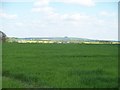
Warwickshire farmland
Looking east from the minor road, Holt Farm is in the middle distance and Highwall Spinney, atop Brailes Hill is on the skyline.
Image: © Michael Dibb
Taken: 4 May 2010
0.21 miles
5
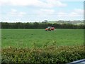
Feeding the crop
Seen from the minor road, fertilizer is being spread.
Image: © Michael Dibb
Taken: 4 May 2010
0.24 miles