IMAGES TAKEN NEAR TO
Admington Lane, SHIPSTON-ON-STOUR, CV36 4JJ
Introduction
This page details the photographs taken nearby to Admington Lane, CV36 4JJ by members of the Geograph project.
The Geograph project started in 2005 with the aim of publishing, organising and preserving representative images for every square kilometre of Great Britain, Ireland and the Isle of Man.

There are currently over 7.5m images from over14,400 individuals and you can help contribute to the project by visiting https://www.geograph.org.uk
Image Map (Loading...)


Getting Data...Please wait
Leaflet Map data © OpenStreetMap
Images are licensed for reuse under creativecommons.org/licenses/by-sa/2.0
Notes
- Clicking on the map will re-center to the selected point.
- The higher the marker number, the further away the image location is from the centre of the postcode.
Image Listing (12 Images Found)
Images are licensed for reuse under creativecommons.org/licenses/by-sa/2.0
Image
Details
Distance
1
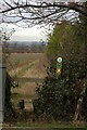
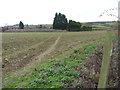
Footpath to Upper Quinton
For a short distance between Ilmington and Upper Quinton the Centenary Way and the Monarch's Way follow the same route.
Image: © Philip Halling
Taken: 2 Feb 2008
0.03 miles
2
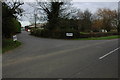
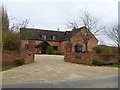
Admington Lane Units
Former Admington Lane Farm now converted into a business centre called Admington Lane Units.
Image: © Philip Halling
Taken: 2 Feb 2008
0.03 miles
3

Admington Lane Units
Originally Admington Lane Farm, part of the farm is now a small business park. The farm has been renamed Willow Farm Image The delightful sign on the post to the left of the roadway has "Cats at work - please slow down". Seen from the minor road.
Image: © Michael Dibb
Taken: 4 Dec 2011
0.03 miles
4
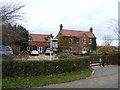
Willow Tree Farm
Originally Admington Lane Farm, part of the farm is now a small business park Image The farm has been renamed Willow Farm. Seen from the minor road.
Image: © Michael Dibb
Taken: 4 Dec 2011
0.03 miles
5
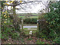
The ways divide
The footpath ends where it meets the minor roads alongside Adminton Lane Units. The Centenary way turns left and heads towards Ilmington. The Monarch's Way turns right and heads to Hidcote Bartrim and Chipping Campden.
Image: © Michael Dibb
Taken: 4 Dec 2011
0.06 miles
6
Towards the farm
The footpath, part of both the Monarch's Way and the Centenary Way, heads towards the minor road and the farm
Image: © Michael Dibb
Taken: 4 Dec 2011
0.07 miles
7
Moon House
This unusually named but undistinguished house is alongside Admington Lane.
Image: © Michael Dibb
Taken: 4 Dec 2011
0.11 miles
8
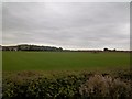
Warwickshire farmland
Seen from the minor road, Admington Lane Farm is to the left with the bulk of Meon Hill (SP1745) behind.
Image: © Michael Dibb
Taken: 26 Sep 2010
0.15 miles
9
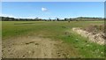
Field beside Admington Lane Farm
Not sure but the field in the foreground may be a polo field. Meon Hill is on the right.
Image: © Philip Halling
Taken: 9 Mar 2017
0.19 miles
10
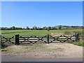
Fields west of Admington Lane
Looking west through a farm gateway, across the fields towards Meon Hill in Image
Image: © David P Howard
Taken: 28 Sep 2011
0.23 miles