IMAGES TAKEN NEAR TO
Clark Close, SHIPSTON-ON-STOUR, CV36 4HJ
Introduction
This page details the photographs taken nearby to Clark Close, CV36 4HJ by members of the Geograph project.
The Geograph project started in 2005 with the aim of publishing, organising and preserving representative images for every square kilometre of Great Britain, Ireland and the Isle of Man.

There are currently over 7.5m images from over14,400 individuals and you can help contribute to the project by visiting https://www.geograph.org.uk
Image Map (Loading...)


Getting Data...Please wait
Leaflet Map data © OpenStreetMap
Images are licensed for reuse under creativecommons.org/licenses/by-sa/2.0
Notes
- Clicking on the map will re-center to the selected point.
- The higher the marker number, the further away the image location is from the centre of the postcode.
Image Listing (119 Images Found)
Images are licensed for reuse under creativecommons.org/licenses/by-sa/2.0
Image
Details
Distance
4
Shipston on Stour
Shipston on Stour is a former wool town on the northern fringe of the Cotswolds.
Image: © Stephen McKay
Taken: 28 Aug 2005
0.12 miles
5
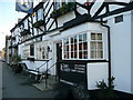
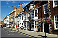
Shipston-on-Stour: the Horse and Shoe pub
Image: © Francois Thomas
Taken: 14 Apr 2008
0.13 miles
6
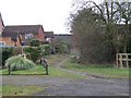
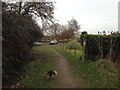
Start of bridleway
From the B4035, Campden Road, the bridleway goes between the houses.
Image: © Michael Dibb
Taken: 31 Jan 2010
0.14 miles
9
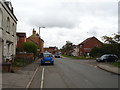
West Street at the junction of Old Road
Image: © David Howard
Taken: 8 Aug 2021
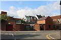
0.15 miles
10

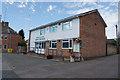
Methodist Church
In London Road, the church built in 1881 replaced a former Methodist Chapel of the 1820s.
Image: © Michael Dibb
Taken: 16 Aug 2010
0.15 miles