IMAGES TAKEN NEAR TO
Jeacock Place, CV35 9UZ
Introduction
This page details the photographs taken nearby to Jeacock Place, CV35 9UZ by members of the Geograph project.
The Geograph project started in 2005 with the aim of publishing, organising and preserving representative images for every square kilometre of Great Britain, Ireland and the Isle of Man.

There are currently over 7.5m images from over14,400 individuals and you can help contribute to the project by visiting https://www.geograph.org.uk
Image Map
Images are licensed for reuse under creativecommons.org/licenses/by-sa/2.0
Notes
- Clicking on the map will re-center to the selected point.
- The higher the marker number, the further away the image location is from the centre of the postcode.
Image Listing (21 Images Found)
Images are licensed for reuse under creativecommons.org/licenses/by-sa/2.0
Image
Details
Distance
1
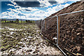
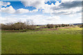
Large earth bank on Ettington Park Estate
Looking due south from the current end of Copeland Avenue, along the line of a very large earth bank, which I suspect is a temporary structure.
Image: © David P Howard
Taken: 5 Apr 2016
0.15 miles
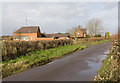
2

Cottages at Laughs Buildings
These semi detached Victorian cottages are at a farm known as Laughs Buildings on the Walton Road just south of Wellesbourne. They have a view over the flood plain of the River Dene toward Wellesbourne water mill.
Image: © Nigel Mykura
Taken: 3 Apr 2011
0.16 miles
3
Walton Road
Looking NNW along Walton Road with a cottage and some buildings in the background named on the map as Laughs Buildings.
Image: © David P Howard
Taken: 6 Jan 2014
0.17 miles
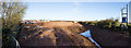
4
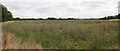
Fields east of Ettington Road
A panoramic view of the fields east of Ettington Road that are about to be developed into a new housing estate. Initial activity can be seen over to the left.
Note how the field, that has grown wheat in the past, has been left to grow weeds.
Image: © David P Howard
Taken: 14 Aug 2013
0.17 miles
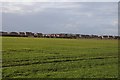
5
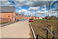
Copeland Avenue, Ettington Park Estate
View north along a row of newly completed houses on the eastern edge of the new housing development.
Image: © David P Howard
Taken: 5 Apr 2016
0.18 miles
6
Drainage pond on eastern edge of housing estate
View east from Copeland Avenue towards the edge of the Ettington Park Estate.
The depressed area in front of the hedge line is a surface water drainage pond.
Image: © David P Howard
Taken: 5 Apr 2016
0.18 miles
7
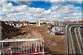
Storage yard on Ettington Park Estate
View west from the current end of Copeland Avenue towards the centre of the Ettington Park Estate.
Image: © David P Howard
Taken: 5 Apr 2016
0.19 miles
8
Modern housing at Wellsbourne
Modern housing at Wellsbourne viewed across a field from Walton Road.
Image: © Philip Halling
Taken: 16 Mar 2018
0.19 miles
9
Panoramic view from Ettington Road
This is a stitched 80 degree panorama from four images, taken using a three metre monopod to secure a high viewing position.
It shows the continued building on the Ettington Park Estate.
Note the huge ditch that has been dug along the hedge line on the right hand side of the photo.
Image: © David P Howard
Taken: 18 Jan 2015
0.19 miles
10
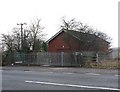
Wellesbourne booster station, Severn Trent Water
The booster station for Wellesbourne at the side of the A429.
Image: © David P Howard
Taken: 18 Jan 2010
0.19 miles