IMAGES TAKEN NEAR TO
Mountford Close, WARWICK, CV35 9QG
Introduction
This page details the photographs taken nearby to Mountford Close, CV35 9QG by members of the Geograph project.
The Geograph project started in 2005 with the aim of publishing, organising and preserving representative images for every square kilometre of Great Britain, Ireland and the Isle of Man.

There are currently over 7.5m images from over14,400 individuals and you can help contribute to the project by visiting https://www.geograph.org.uk
Image Map
Images are licensed for reuse under creativecommons.org/licenses/by-sa/2.0
Notes
- Clicking on the map will re-center to the selected point.
- The higher the marker number, the further away the image location is from the centre of the postcode.
Image Listing (59 Images Found)
Images are licensed for reuse under creativecommons.org/licenses/by-sa/2.0
Image
Details
Distance
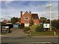
1
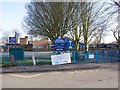
Wellesbourne C of E Primary School
This is the main building in Mountford Close. http://www.wellesbourneceprimary.co.uk/index.php
The close is a rectangular cul-de-sac, and relatively narrow. The sign on the railings exhorts motorists to observe a voluntary keep left policy, by saying "Turn this way to make our day". At school opening and closing times the road is very busy, and almost everybody who is local observes the policy.
Image: © David P Howard
Taken: 17 Feb 2013
0.01 miles
2
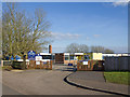
Wellesbourne C of E Primary School
This is the Annexe to the main site, which is about 200 metres south west.
The Annexe covers nursery, reception and key stage 1 classes. http://www.wellesbourneceprimary.co.uk/index.php
Image: © David P Howard
Taken: 17 Feb 2013
0.10 miles
3
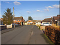
Mountford Close
Mountford Close is a rectangular cul-de-sac. This is the eastern corner.
Image: © David P Howard
Taken: 17 Feb 2013
0.10 miles
4
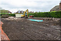
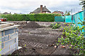
The site of the old Police Station
The building site left a few days after the Police Station was demolished to make way for four new houses.
For a view of the station in September 2011 just before closure, see Image
Image: © David P Howard
Taken: 6 Apr 2014
0.10 miles
5
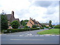
Wellesbourne-Kineton Road
Houses near the junction with Newbold Road.
Image: © Ian Rob
Taken: 25 Jul 2009
0.11 miles
6
Newbold Place, Wellesbourne
Seen from Newbold Road.
Image: © Stuart Shepherd
Taken: 23 Jul 2009
0.11 miles
7
The site of the old Police Station
The building site left a few days after the Police Station was demolished to make way for four new houses.
For a view of the station in September 2011 just before closure, see Image
Image: © David P Howard
Taken: 6 Apr 2014
0.11 miles
8
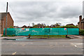
The Police Station is no more
The site that was occupied by Wellesbourne Police Station a few days after it was demolished to make way for four new houses.
For a view in September 2011, shortly before it closed, see Image
For a closer view of the site see Image
Image: © David P Howard
Taken: 6 Apr 2014
0.11 miles
9
The Police Station, Wellesbourne
The Police Station at Wellesbourne is currently used as a patrol base, but is destined to be closed and sold off as housing, as part of the spending cuts. http://www.bbc.co.uk/news/uk-england-coventry-warwickshire-14663714 http://www.warwickshire.police.uk/policingwarwickshire/policestations/Wellsbourneps?
For a view in April 2014, just after demolition see Image
Image: © David P Howard
Taken: 4 Sep 2011
0.11 miles
10
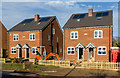
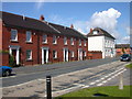
Four new houses nearly finished
These four new houses on the site of the old Police Station are nearly finished.
For a view of the old Police Station see Image
Image: © David P Howard
Taken: 12 Nov 2014
0.11 miles