IMAGES TAKEN NEAR TO
Staple Hill, WARWICK, CV35 9LH
Introduction
This page details the photographs taken nearby to Staple Hill, CV35 9LH by members of the Geograph project.
The Geograph project started in 2005 with the aim of publishing, organising and preserving representative images for every square kilometre of Great Britain, Ireland and the Isle of Man.

There are currently over 7.5m images from over14,400 individuals and you can help contribute to the project by visiting https://www.geograph.org.uk
Image Map
Images are licensed for reuse under creativecommons.org/licenses/by-sa/2.0
Notes
- Clicking on the map will re-center to the selected point.
- The higher the marker number, the further away the image location is from the centre of the postcode.
Image Listing (14 Images Found)
Images are licensed for reuse under creativecommons.org/licenses/by-sa/2.0
Image
Details
Distance
1
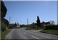
Wellesbourne-Staple Hill
Cottages and farmhouse on the road to Lighthorne.
Image: © Ian Rob
Taken: 9 Apr 2011
0.04 miles
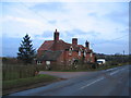
3
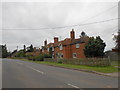
Cottages at Staple Hill
This row of cottages were probably workers cottages associated with Staple Hill Farm, a very large mixed farm just east of Wellesbourne. They are now separate residences. They are on the minor road that runs from the Kineton Rd to Moreton Paddox.
Image: © Nigel Mykura
Taken: 2 Sep 2012
0.05 miles
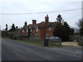
5
Cottages at Staple Hill
Beside the Wellesbourne to Lighthorne road.
Image: © David Stowell
Taken: 15 Jan 2006
0.07 miles
6
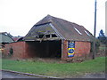
Ripe for Conversion
.. and up for sale. A golden opportunity for anyone who wishes to live next to Staple Hill House on the lane from Wellesbourne to Lighthorne.
Image: © David Stowell
Taken: 15 Jan 2006
0.07 miles

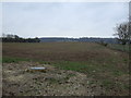
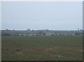
9
Staple Hill Farm
View West across fields towards Staple Hill Farm in centre. To right is Staple Hill House (partially in SP2955). Wellesbourne village is in the distance.
Image: © David P Howard
Taken: 4 Jan 2010
0.12 miles
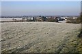
10

The sun sets over Wellesbourne
The mid June evening sun starts to set over Wellesbourne, as a geological guided walk by the Warwickshire Geological Conservation Group makes its way along the lane near to Staple House Farm.
Image: © David P Howard
Taken: 19 Jun 2013
0.12 miles