IMAGES TAKEN NEAR TO
Loxley, WARWICK, CV35 9JR
Introduction
This page details the photographs taken nearby to CV35 9JR by members of the Geograph project.
The Geograph project started in 2005 with the aim of publishing, organising and preserving representative images for every square kilometre of Great Britain, Ireland and the Isle of Man.

There are currently over 7.5m images from over14,400 individuals and you can help contribute to the project by visiting https://www.geograph.org.uk
Image Map
Images are licensed for reuse under creativecommons.org/licenses/by-sa/2.0
Notes
- Clicking on the map will re-center to the selected point.
- The higher the marker number, the further away the image location is from the centre of the postcode.
Image Listing (1 Images Found)
Images are licensed for reuse under creativecommons.org/licenses/by-sa/2.0
Image
Details
Distance
1
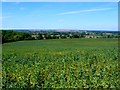
Countryside near Loxley
This square only has a very tiny piece of public road in it in the south east corner from where this photo was taken near Goldicote Lodge. the trees on the right are Goldicote copse.
Image: © Nigel Mykura
Taken: 24 Jul 2011
0.20 miles