IMAGES TAKEN NEAR TO
Charlecote, WARWICK, CV35 9EH
Introduction
This page details the photographs taken nearby to CV35 9EH by members of the Geograph project.
The Geograph project started in 2005 with the aim of publishing, organising and preserving representative images for every square kilometre of Great Britain, Ireland and the Isle of Man.

There are currently over 7.5m images from over14,400 individuals and you can help contribute to the project by visiting https://www.geograph.org.uk
Image Map
Images are licensed for reuse under creativecommons.org/licenses/by-sa/2.0
Notes
- Clicking on the map will re-center to the selected point.
- The higher the marker number, the further away the image location is from the centre of the postcode.
Image Listing (2 Images Found)
Images are licensed for reuse under creativecommons.org/licenses/by-sa/2.0
Image
Details
Distance
1

Middle Hill Farm
This farm stands alone in the middle of the grid square with this drive as the only vehicular access. The track is also a bridle path to Newbold Pacey
Image: © Nigel Mykura
Taken: 16 Apr 2012
0.05 miles
2
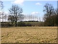
Middle Hall Farm
View SW towards Middle Hall Farm from the Woozeley Bridge to Wasperton footpath.
Image: © David P Howard
Taken: 14 Feb 2010
0.10 miles