IMAGES TAKEN NEAR TO
N V Side, WARWICK, CV35 9ED
Introduction
This page details the photographs taken nearby to N V Side, CV35 9ED by members of the Geograph project.
The Geograph project started in 2005 with the aim of publishing, organising and preserving representative images for every square kilometre of Great Britain, Ireland and the Isle of Man.

There are currently over 7.5m images from over14,400 individuals and you can help contribute to the project by visiting https://www.geograph.org.uk
Image Map
Images are licensed for reuse under creativecommons.org/licenses/by-sa/2.0
Notes
- Clicking on the map will re-center to the selected point.
- The higher the marker number, the further away the image location is from the centre of the postcode.
Image Listing (14 Images Found)
Images are licensed for reuse under creativecommons.org/licenses/by-sa/2.0
Image
Details
Distance
1
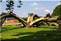
Oak tree struck by lightning
This oak tree just off the footpath through the grounds of the Warwick University site, has been struck by lightning in the last few days, and split into three.
The area had been cordoned off with marker tape, and work had started to clear the debris away.
The tree fell just touching a workshop block, but appeared luckily to have done no damage.
Image: © David P Howard
Taken: 23 Jul 2014
0.05 miles
2
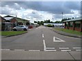
University of Warwick, Wellesbourne Campus
Looking south from near the southern edge of the grid square, down one of the side roads that come off the main road that is also a public footpath. The footpath runs through the middle of the site, designated Warwick Crop Centre. http://www2.warwick.ac.uk/fac/sci/lifesci/wcc
Image: © David P Howard
Taken: 14 Aug 2012
0.07 miles
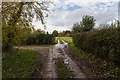
3
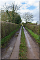
Unclassified country road
Short section of unclassified country road running through the Wellesbourne Campus of Warwick University.
Image: © David P Howard
Taken: 12 Nov 2014
0.09 miles
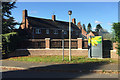
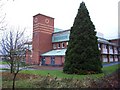
4
Wellesbourne Horticultural Research Institute
For many years this was a Government Research Institution, latterly under the auspices of Defra. Since the 1st April 2004 however it has been taken over and integrated into the University of Warwick.
Image: © David Stowell
Taken: 4 Feb 2006
0.13 miles
5
Unclassified country road
Short section of unclassified country road running through the Wellesbourne Campus of Warwick University.
Image: © David P Howard
Taken: 12 Nov 2014
0.14 miles
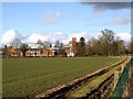
6
Houses on the University of Warwick's Wellesbourne Campus
Formerly Horticulture Research International, formerly Wellesbourne Horticultural Research Institute: see David Stowell's Image
Image: © Robin Stott
Taken: 27 Oct 2017
0.15 miles
7
Horticulture Research International, Wellesbourne
Part of the University of Warwick.
Image: © David P Howard
Taken: 21 Feb 2010
0.16 miles
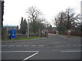
8
Glasshouses, Warwick Crop Centre
View west from the A429 across to a range of glasshouses forming part of Warwick University's Wellesbourne Campus, Warwick Crop Centre http://www2.warwick.ac.uk/fac/sci/lifesci/wcc
Image: © David P Howard
Taken: 26 May 2012
0.17 miles
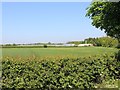
10
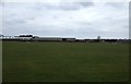
Sports ground, Wellesbourne Horticultural Research Institute
Image: © JThomas
Taken: 4 Apr 2013
0.18 miles