IMAGES TAKEN NEAR TO
Wellesbourne, WARWICK, CV35 9EB
Introduction
This page details the photographs taken nearby to CV35 9EB by members of the Geograph project.
The Geograph project started in 2005 with the aim of publishing, organising and preserving representative images for every square kilometre of Great Britain, Ireland and the Isle of Man.

There are currently over 7.5m images from over14,400 individuals and you can help contribute to the project by visiting https://www.geograph.org.uk
Image Map
Images are licensed for reuse under creativecommons.org/licenses/by-sa/2.0
Notes
- Clicking on the map will re-center to the selected point.
- The higher the marker number, the further away the image location is from the centre of the postcode.
Image Listing (6 Images Found)
Images are licensed for reuse under creativecommons.org/licenses/by-sa/2.0
Image
Details
Distance
1
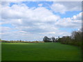
Little Hill
Hidden in the trees on the right can be seen some of the buildings at Little Hill. It is a large working mixed farm with both arable and stock. The track to the farm from the A429 is behind the hedge on the right.
Image: © Nigel Mykura
Taken: 16 Apr 2012
0.02 miles
2
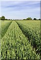
Wheat field by the footpath
View northwest from the footpath from Wellesbourne to Newbold Pacey, across a wheat field.
In the distance is Little Hill Farm in Image
Image: © David P Howard
Taken: 6 Jun 2014
0.15 miles
3
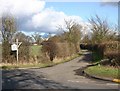
Entrance to Little Hill Farm
View NE up the entrance drive off the A429.
Image: © David P Howard
Taken: 21 Feb 2010
0.19 miles
4
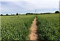
Footpath to Newbold Pacey
The footpath from Wellesbourne to Newbold Pacey passes through a wheat field.
Image: © David P Howard
Taken: 6 Jun 2014
0.19 miles
5
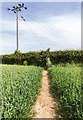
Footpath to Newbold Pacey
The footpath from Wellesbourne to Newbold Pacey passes through a wheat field.
Image: © David P Howard
Taken: 6 Jun 2014
0.19 miles
6
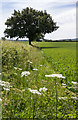
Field margin by the footpath
View southeast from the footpath from Wellesbourne to Newbold Pacey.
Image: © David P Howard
Taken: 6 Jun 2014
0.23 miles