IMAGES TAKEN NEAR TO
Newbold Pacey, WARWICK, CV35 9DY
Introduction
This page details the photographs taken nearby to CV35 9DY by members of the Geograph project.
The Geograph project started in 2005 with the aim of publishing, organising and preserving representative images for every square kilometre of Great Britain, Ireland and the Isle of Man.

There are currently over 7.5m images from over14,400 individuals and you can help contribute to the project by visiting https://www.geograph.org.uk
Image Map
Images are licensed for reuse under creativecommons.org/licenses/by-sa/2.0
Notes
- Clicking on the map will re-center to the selected point.
- The higher the marker number, the further away the image location is from the centre of the postcode.
Image Listing (5 Images Found)
Images are licensed for reuse under creativecommons.org/licenses/by-sa/2.0
Image
Details
Distance
1
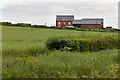
New houses at Flint Hall Cottages
Two new luxury houses have been built on the site of Flint Hall Cottages, east of Newbold Road.
Image: © David P Howard
Taken: 6 Jun 2014
0.02 miles
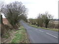
4
Newbold Road (B4087) between Wellesbourne and Newbold Pacey
Looking north-eastward.
Image: © Peter Wood
Taken: 4 Nov 2017
0.21 miles
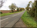
5
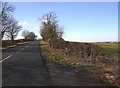
Newbold Road, Newbold Pacey
Looking SW along Newbold Road just outside Newbold Pacey.
Image: © David P Howard
Taken: 14 Feb 2010
0.24 miles