IMAGES TAKEN NEAR TO
Pipers Bath, WARWICK, CV35 9DQ
Introduction
This page details the photographs taken nearby to Pipers Bath, CV35 9DQ by members of the Geograph project.
The Geograph project started in 2005 with the aim of publishing, organising and preserving representative images for every square kilometre of Great Britain, Ireland and the Isle of Man.

There are currently over 7.5m images from over14,400 individuals and you can help contribute to the project by visiting https://www.geograph.org.uk
Image Map
Images are licensed for reuse under creativecommons.org/licenses/by-sa/2.0
Notes
- Clicking on the map will re-center to the selected point.
- The higher the marker number, the further away the image location is from the centre of the postcode.
Image Listing (10 Images Found)
Images are licensed for reuse under creativecommons.org/licenses/by-sa/2.0
Image
Details
Distance
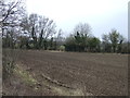
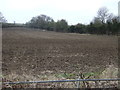
1
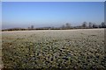
Bath Copse
View North from fields by Westfield Farm towards Bath Copse in the distance.
Image: © David P Howard
Taken: 4 Jan 2010
0.11 miles

6
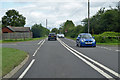
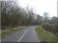
B4455 Fosse Way heading north
Moreton Morrell left, Lighthorne right.
Image: © Robin Webster
Taken: 11 Aug 2019
0.20 miles
9
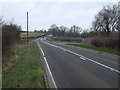
The entrance to Far Westfield Farm
The sign says 'Far Westfield Farm and Racing Stables' whereas the map has 'Far Westfields Farm' (plural).
Image: © David Purchase
Taken: 11 May 2014
0.24 miles
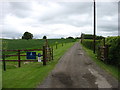
10
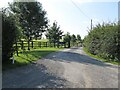
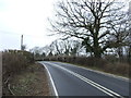
Lighthorne-Far Westfield Farm
Gateway to the Farm.
Image: © Ian Rob
Taken: 4 Aug 2021
0.24 miles