IMAGES TAKEN NEAR TO
Budbrooke, WARWICK, CV35 8QJ
Introduction
This page details the photographs taken nearby to CV35 8QJ by members of the Geograph project.
The Geograph project started in 2005 with the aim of publishing, organising and preserving representative images for every square kilometre of Great Britain, Ireland and the Isle of Man.

There are currently over 7.5m images from over14,400 individuals and you can help contribute to the project by visiting https://www.geograph.org.uk
Image Map
Images are licensed for reuse under creativecommons.org/licenses/by-sa/2.0
Notes
- Clicking on the map will re-center to the selected point.
- The higher the marker number, the further away the image location is from the centre of the postcode.
Image Listing (23 Images Found)
Images are licensed for reuse under creativecommons.org/licenses/by-sa/2.0
Image
Details
Distance
1
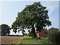
Oak tree and cottage near Budbrooke Farm
Image: © Jonathan Thacker
Taken: 16 Sep 2020
0.01 miles
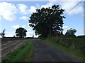
3
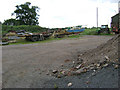
Budbrooke Farm
The only publicly accessible area in the North Eastern corner of this square.
Image: © David Stowell
Taken: 18 Apr 2005
0.02 miles
4
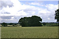
A hidden pond near Budbrooke Farm
Another instance of a pond (with water in it) hemmed in by mature trees. On the horizon: Leamington Spa, left; Warwick, right.
Image: © Robin Stott
Taken: 13 Jul 2009
0.02 miles
5
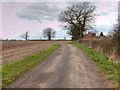
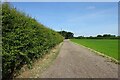
Driveway to Budbrooke Farm
The driveway is also a public footpath towards Hatton.
Image: © David P Howard
Taken: 14 Mar 2013
0.04 miles
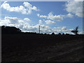
8
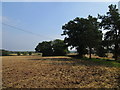
Harrowed field near Budbrooke Farm
Image: © Jonathan Thacker
Taken: 16 Sep 2020
0.06 miles
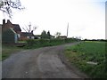
9
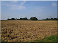
Stubble field
Looking towards Budbrooke Farm.
Image: © Jonathan Thacker
Taken: 16 Sep 2020
0.10 miles