IMAGES TAKEN NEAR TO
Pinley Green, WARWICK, CV35 8LU
Introduction
This page details the photographs taken nearby to Pinley Green, CV35 8LU by members of the Geograph project.
The Geograph project started in 2005 with the aim of publishing, organising and preserving representative images for every square kilometre of Great Britain, Ireland and the Isle of Man.

There are currently over 7.5m images from over14,400 individuals and you can help contribute to the project by visiting https://www.geograph.org.uk
Image Map
Images are licensed for reuse under creativecommons.org/licenses/by-sa/2.0
Notes
- Clicking on the map will re-center to the selected point.
- The higher the marker number, the further away the image location is from the centre of the postcode.
Image Listing (16 Images Found)
Images are licensed for reuse under creativecommons.org/licenses/by-sa/2.0
Image
Details
Distance
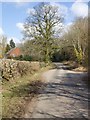
1

Redeveloped cottages, Pinley Green
Seen from the lane to Pinley Rudding.
Image: © Robin Stott
Taken: 3 May 2011
0.04 miles
2
Sheep in the shade
By the lane to Pinley Rudding.
Image: © Robin Stott
Taken: 3 May 2011
0.11 miles
3
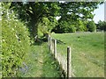
Fenced footpath nearing Pinley Green
People who keep a few horses and sheep increasingly fence off the public footpaths over their land, as here. Further along it gets worse: weedy footpath hemmed in between a ditch and a high fence.
Image: © Robin Stott
Taken: 3 May 2011
0.12 miles
4
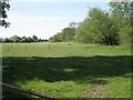
Horsebox, man?ge and paddock, Pinley Green
A common sight.
Image: © Robin Stott
Taken: 3 May 2011
0.13 miles
5
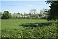
Line of a brook, southwest from Pinley Green
This is the north end of the long wide flat grass strip seen in Image - conceivably a World War II landing strip.
Image: © Robin Stott
Taken: 3 May 2011
0.13 miles
6
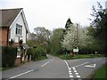
Pinley Green
In the centre of the village
Image: © David Stowell
Taken: 22 Apr 2005
0.15 miles
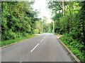
8
Manor Lane
Looking NNW down Manor Lane as it enters Pinley Green.
Image: © David P Howard
Taken: 3 Apr 2013
0.18 miles
9

Garden and signpost
A glimpse of the front garden of the red brick Oakball Cottage, which stands at the Pinley crossroads. The old-style signpost above the hedge indicates the distances to Lowsonford 2 (ahead), Claverdon 1 and Henley in Arden 4 (left) and Haseley 2 or Warwick 5 (right). For a view from the other side of the hedge 47 years later, see Image The modern direction signs show a different set of destinations (Shrewley 1, Holywell and Hatton Station) and the brick walls of the cottage have been rendered.
Image: © Tiger
Taken: 1 Jul 1964
0.18 miles
10
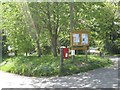
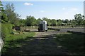
Postbox and parish noticeboard, Pinley Green
Postbox number CV35 86. Parish of Rowington. The lane to the left is the direction for Hatton station, SP2266; Manor Lane to the right swings southwest towards Claverdon, SP1964.
Image: © Robin Stott
Taken: 3 May 2011
0.19 miles