IMAGES TAKEN NEAR TO
Henley Road, WARWICK, CV35 8LJ
Introduction
This page details the photographs taken nearby to Henley Road, CV35 8LJ by members of the Geograph project.
The Geograph project started in 2005 with the aim of publishing, organising and preserving representative images for every square kilometre of Great Britain, Ireland and the Isle of Man.

There are currently over 7.5m images from over14,400 individuals and you can help contribute to the project by visiting https://www.geograph.org.uk
Image Map
Images are licensed for reuse under creativecommons.org/licenses/by-sa/2.0
Notes
- Clicking on the map will re-center to the selected point.
- The higher the marker number, the further away the image location is from the centre of the postcode.
Image Listing (32 Images Found)
Images are licensed for reuse under creativecommons.org/licenses/by-sa/2.0
Image
Details
Distance
1
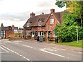
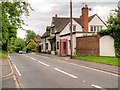
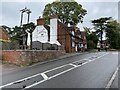
Claverdon, The Crown Inn
The Crown Inn, Henley Road, Claverdon
Image: © David Dixon
Taken: 3 Jul 2013
0.01 miles
2
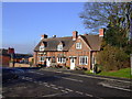
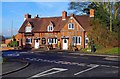
Old house, Henley Road, Claverdon, Warwicks
Interesting old house with bicycles attached to the side wall.
Image: © P L Chadwick
Taken: 3 Feb 2015
0.01 miles
3
Crown Inn, Claverdon
Nice traditional local with Brew XI to bring back memories of Cape Hill and a guest beer.
Image: © al partington
Taken: 7 Feb 2007
0.02 miles
4
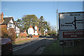
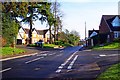
A4189 Henley Road entering Claverdon
The road climbs to the village centre and levels out on a plateau. The Crown Inn is just left of centre. The postbox number is CV35 5.
Image: © Robin Stott
Taken: 10 Nov 2010
0.03 miles
5
Claverdon, Henley Road
The A4189 passing through Claverdon Village.
Image: © David Dixon
Taken: 3 Jul 2013
0.03 miles
6
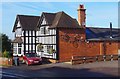
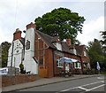
Crown Inn (1), Henley Road, Claverdon, Warwicks
Located on the A4189 road opposite a road called Highcroft. The publishers, Francis Frith, who have a photographic archive dasting back to 1860, have a photograph of this pub dating from around 1960. At the time the building was white-washed and displayed in large lettering the name of the brewery Hunt Edmunds. It was based in Banbury, Oxfordshire and its brewery was soon demolished after the company was swallowed up in the 1960's by the vast Bass, Mitchells & Butlers empire.
Image
Image: © P L Chadwick
Taken: 3 Feb 2015
0.04 miles
7
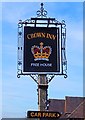
Crown Inn (2) - sign, Henley Road, Claverdon, Warwicks
The sign is on a post outside the front of the pub. Using the name The Crown indicated loyalty to the reigning monarch, which in the past was always a wise thing to do. The name has been used for inns or pubs for hundreds of years. In the past, when most people were illiterate, the sign was easily recognised by people. The Crown is almost as popular as a pub name as the Red Lion.
Image
Image: © P L Chadwick
Taken: 3 Feb 2015
0.04 miles
9
The Crown Inn Claverdon
Update of https://www.geograph.org.uk/photo/5399847 from 2017.
Image: © Mike Dodman
Taken: 3 Sep 2024
0.04 miles
10
Junction of Henley Road (A4189) and Highcroft, Claverdon, Warwicks
Highcroft is on the right.
Image: © P L Chadwick
Taken: 3 Feb 2015
0.05 miles