IMAGES TAKEN NEAR TO
Wolverton Road, WARWICK, CV35 8JL
Introduction
This page details the photographs taken nearby to Wolverton Road, CV35 8JL by members of the Geograph project.
The Geograph project started in 2005 with the aim of publishing, organising and preserving representative images for every square kilometre of Great Britain, Ireland and the Isle of Man.

There are currently over 7.5m images from over14,400 individuals and you can help contribute to the project by visiting https://www.geograph.org.uk
Image Map
Images are licensed for reuse under creativecommons.org/licenses/by-sa/2.0
Notes
- Clicking on the map will re-center to the selected point.
- The higher the marker number, the further away the image location is from the centre of the postcode.
Image Listing (33 Images Found)
Images are licensed for reuse under creativecommons.org/licenses/by-sa/2.0
Image
Details
Distance
1
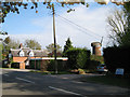
The windmill, Norton Lindsey
Seen across Wolverton Road.
Image: © Robin Stott
Taken: 3 May 2010
0.03 miles
2
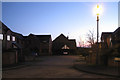
Mill Close, dusk
One of several small residential developments which have enlarged the village discreetly. Just after 5pm GMT.
Image: © Robin Stott
Taken: 18 Jan 2011
0.04 miles
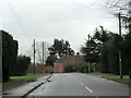
3
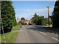
Wolverton Road, Norton Lindsey
Detached properties, well set back, line both sides of Wolverton Road.
Image: © Robin Stott
Taken: 3 May 2010
0.05 miles
4

Cake stop at Norton Lindsey
The village hall at Norton Lindsey hosting a cake stop for a charity cycle ride.
Image: © Michael Trolove
Taken: 29 Mar 2009
0.05 miles
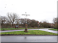
5

Norton Lindsey village hall
With the cricket pavilion beyond. The village enjoys a wide range of sporting and social activities.
Image: © Robin Stott
Taken: 3 May 2010
0.08 miles
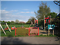
7
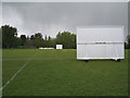
Norton Lindsey sports field
Cricket in the Tapster valley has an interesting history. http://www.nlwcc.co.uk/history/default.aspx
Image: © Robin Stott
Taken: 3 May 2010
0.08 miles
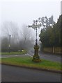
9
The Victoria signpost, Norton Lindsey
My local guide tells me this ornate fingerpost, erected in 1897 for Queen Victoria's Diamond Jubilee, is known by locals as the Victoria signpost to differentiate it from a later one in the village called the Elizabeth signpost. It is grade II listed (list entry 1035191).
Image: © Stephen Craven
Taken: 9 Feb 2020
0.11 miles
10
Norton Lindsey, fingerpost
At the corner of Main Street / New Road / Wards Hill, an elaborate fingerpost, commemorating the Diamond Jubilee of Queen Victoria; listed by English Heritage: http://www.imagesofengland.org.uk/Details/Default.aspx?id=308098&mode=adv An unclear image because of morning winter mist.
Image: © Mike Faherty
Taken: 17 Feb 2013
0.11 miles