IMAGES TAKEN NEAR TO
Morgan Close, WARWICK, CV35 8JF
Introduction
This page details the photographs taken nearby to Morgan Close, CV35 8JF by members of the Geograph project.
The Geograph project started in 2005 with the aim of publishing, organising and preserving representative images for every square kilometre of Great Britain, Ireland and the Isle of Man.

There are currently over 7.5m images from over14,400 individuals and you can help contribute to the project by visiting https://www.geograph.org.uk
Image Map
Images are licensed for reuse under creativecommons.org/licenses/by-sa/2.0
Notes
- Clicking on the map will re-center to the selected point.
- The higher the marker number, the further away the image location is from the centre of the postcode.
Image Listing (19 Images Found)
Images are licensed for reuse under creativecommons.org/licenses/by-sa/2.0
Image
Details
Distance
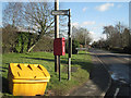
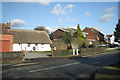
1
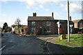
Red Horse Corner
The village street continues to the left as Wolverton Road. Postbox number CV35 208 hangs around on the corner of Curlieu Lane along with some other street furniture mates.
Image: © Robin Stott
Taken: 18 Jan 2011
0.04 miles
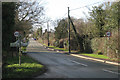
2
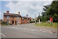
Wolverton Road at Curlieu Lane, Norton Lindsey
Image: © Ian S
Taken: 26 Jul 2021
0.04 miles
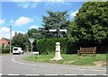
4
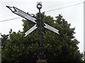
Fingerpost, Norton Lindsey
At the NE corner of the junction of Wolverton Road and Curlieu Lane. With a crown finial.
A context image is Image
It was erected for the 70ᵗʰ jubilee of the reign of Queen Elizabeth II.
There is a companion of a similarly ornate signpost for Queen Victoria's jubilee -
see Image
Inscription: Wolverton 1¼ / Bearley 4 // Warwick 4 / village Hall // Claverdon 2¼ / Henley 5¼
Milestone Society National ID: WA_SP2263D
Image: © Mr Red
Taken: 27 Jul 2024
0.05 miles
5
The public domain
Street furniture, a telephone pole, inspection covers, a bus stop, a visibility splay and the highway itself near Red Horse Corner, with postbox number CV35 208.
Image: © Robin Stott
Taken: 18 Jan 2011
0.07 miles
6
District boundary crosses Wolverton Road
Norton Lindsey straggles across the line between Warwick District and (sometimes hyphenated) Stratford on Avon District. Stratford town is Stratford-upon-Avon. The view is from the corner of Norton Lea into Image
Image: © Robin Stott
Taken: 18 Jan 2011
0.09 miles
7
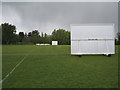
Norton Lindsey sports field
Cricket in the Tapster valley has an interesting history. http://www.nlwcc.co.uk/history/default.aspx
Image: © Robin Stott
Taken: 3 May 2010
0.11 miles
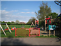
9
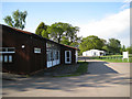
Norton Lindsey village hall
With the cricket pavilion beyond. The village enjoys a wide range of sporting and social activities.
Image: © Robin Stott
Taken: 3 May 2010
0.11 miles
10
House types, Wolverton Road
Seen from the corner of Norton Lea.
Image: © Robin Stott
Taken: 18 Jan 2011
0.11 miles