IMAGES TAKEN NEAR TO
Carter Drive, WARWICK, CV35 8ET
Introduction
This page details the photographs taken nearby to Carter Drive, CV35 8ET by members of the Geograph project.
The Geograph project started in 2005 with the aim of publishing, organising and preserving representative images for every square kilometre of Great Britain, Ireland and the Isle of Man.

There are currently over 7.5m images from over14,400 individuals and you can help contribute to the project by visiting https://www.geograph.org.uk
Image Map
Images are licensed for reuse under creativecommons.org/licenses/by-sa/2.0
Notes
- Clicking on the map will re-center to the selected point.
- The higher the marker number, the further away the image location is from the centre of the postcode.
Image Listing (92 Images Found)
Images are licensed for reuse under creativecommons.org/licenses/by-sa/2.0
Image
Details
Distance
2
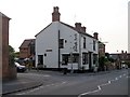
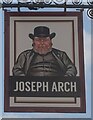
The Joseph Arch public house
On Bridge Street Barford.
Image: © Steve Fareham
Taken: 22 Jul 2008
0.07 miles
3
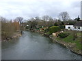
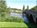
The old bridge from the new bridge
View East from the new A429 Barford by-pass bridge over the Avon, towards the old bridge which now just serves the village and local traffic.
Compare with a photo of the river in flood. Image
Image: © David P Howard
Taken: 31 Jan 2010
0.08 miles
4
Barford,The River Avon
A view of the Warwickshire River Avon on the downstream side of Barford bridge.
Image: © D Holte
Taken: 15 Jul 2012
0.08 miles
6
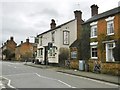
Barford, Joseph Arch
Village pub on Bridge Street, a former coaching inn. Internally, a traditional two room layout; central bar, with public bar left, and lounge right. TV, games machine, darts, garden. Cask ales on offer at my visit: Fuller's London Pride, Wye Valley HPA. The pub is named after the founder of the National Union of Agricultural Labourers. The building is C19, and listed by Historic England: http://www.imagesofengland.org.uk/Details/Default.aspx?id=307906&mode=adv
Image: © Mike Faherty
Taken: 19 Feb 2017
0.08 miles
7
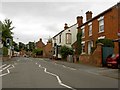
Minor road crossing Barford Bridge
Until the bypass was built the Barford Bridge was on the main A429 Warwick to Cirencester road.
Image: © Philip Halling
Taken: 18 Apr 2018
0.09 miles
8
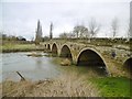
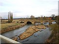
Barford Bridge
Carrying Bridge Street (formerly A429) over River Avon. The bridge is C18, and listed by Historic England: http://www.imagesofengland.org.uk/Details/Default.aspx?id=307903&mode=adv
Image: © Mike Faherty
Taken: 19 Feb 2017
0.09 miles
9
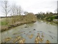
Barford, River Avon
Looking upstream from Image
Image: © Mike Faherty
Taken: 19 Feb 2017
0.09 miles