IMAGES TAKEN NEAR TO
Wellesbourne Road, WARWICK, CV35 8EL
Introduction
This page details the photographs taken nearby to Wellesbourne Road, CV35 8EL by members of the Geograph project.
The Geograph project started in 2005 with the aim of publishing, organising and preserving representative images for every square kilometre of Great Britain, Ireland and the Isle of Man.

There are currently over 7.5m images from over14,400 individuals and you can help contribute to the project by visiting https://www.geograph.org.uk
Image Map
Images are licensed for reuse under creativecommons.org/licenses/by-sa/2.0
Notes
- Clicking on the map will re-center to the selected point.
- The higher the marker number, the further away the image location is from the centre of the postcode.
Image Listing (86 Images Found)
Images are licensed for reuse under creativecommons.org/licenses/by-sa/2.0
Image
Details
Distance
1
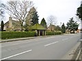
Barford, bus shelter
On Wellesbourne Road.
Image: © Mike Faherty
Taken: 19 Feb 2017
0.04 miles
2
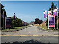
Entrance to Nursery Meadow
A new housing development by Taylor Wimpey off Wellesbourne Road.
Image: © David P Howard
Taken: 9 Jun 2016
0.05 miles
3
Mini Roundabout at Barford
The junction of Bridge Street, Church Street and Wellesbourne Road.
Image: © David Dixon
Taken: 5 Jul 2013
0.05 miles
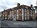
4
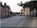
Barford
The junction of Bridge Street, Church Street and Wellesbourne Road.
Image: © David Dixon
Taken: 5 Jul 2013
0.06 miles
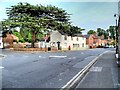
6
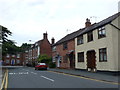
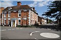
Barford
This is the centre of the village where Church Street (foreground) meets Bridge Street and the Wellesbourne Road which used to carry a lot of traffic going south from Warwick to Wellesbourne and the Fosse Way but the village has now been bypassed.
Image: © Nigel Mykura
Taken: 3 Jul 2011
0.06 miles
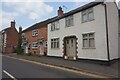
7
Barford, Cedar House
Imposing C18 house at the corner of Bridge and Church Streets; listed by Historic England: http://www.imagesofengland.org.uk/Details/Default.aspx?id=307899&mode=adv
Image: © Mike Faherty
Taken: 19 Feb 2017
0.06 miles
9
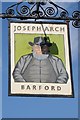
Joseph Arch inn sign
The inn sign to the Joseph Arch public house in the village of Barford Image
Image: © Philip Halling
Taken: 18 Apr 2018
0.06 miles
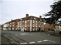
10
Cedar House in Barford
Cedar House stands on the corner of Bridge Street and Church Street in Barford. The house appears to be Georgian, however, the Historic England website records this as being a little earlier, dating from around 1700. It is interesting to see three windows are bricked up, spoiling the symmetry of the house, this can often be seen in older houses where the owner had windows blocked to reduce their window tax. Window tax imposed in England in 1696 and was finally abolished in 1851.
During the 19th century Cedar House was a coffee shop. Louisa Anne Ryland who lived at nearby Sherbourne Park disapproved of public houses and used her influence to have the village's only pub closed, the coffee shop offered an alternative meeting place to residents. Closing pubs and the proliferation of coffee houses has echoes in the 21st Century. Ryland was an only child and inherited the family fortune made from the wire drawing industry. Born in Edgbaston in Birmingham, she was a great beneficiary to the city of Birmingham, donating land for parks such as Cannon Hill Park and Small Heath Park in the city.
Image: © Philip Halling
Taken: 18 Apr 2018
0.07 miles