IMAGES TAKEN NEAR TO
Haseley Knob, WARWICK, CV35 7NJ
Introduction
This page details the photographs taken nearby to CV35 7NJ by members of the Geograph project.
The Geograph project started in 2005 with the aim of publishing, organising and preserving representative images for every square kilometre of Great Britain, Ireland and the Isle of Man.

There are currently over 7.5m images from over14,400 individuals and you can help contribute to the project by visiting https://www.geograph.org.uk
Image Map
Images are licensed for reuse under creativecommons.org/licenses/by-sa/2.0
Notes
- Clicking on the map will re-center to the selected point.
- The higher the marker number, the further away the image location is from the centre of the postcode.
Image Listing (16 Images Found)
Images are licensed for reuse under creativecommons.org/licenses/by-sa/2.0
Image
Details
Distance
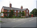
1
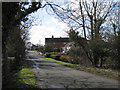
Haseley Knob
A low shoulder of land pushes east across a straight street and the resulting slight elevation gives the hamlet its name. So it is said.
Image: © Robin Stott
Taken: 21 Mar 2010
0.04 miles
2
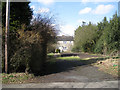
Set-back cottage, Haseley Knob
It has escaped gentrification so far.
Image: © Robin Stott
Taken: 21 Mar 2010
0.11 miles
3
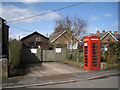
Phone box and BT compound, Haseley Knob
Image: © Robin Stott
Taken: 21 Mar 2010
0.12 miles
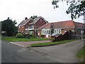
5
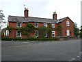
Crossroads at Haseley Knob
This impressive large red brick house once stood on the main road through the village but the A4177 has now bypassed the village and it can now only be accessed by the road south past Cheney's Farm.
Image: © Nigel Mykura
Taken: 9 Oct 2011
0.13 miles
6
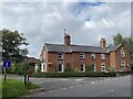
Haseley Knob
House at road junction to Beausale.
Image: © Alan Hughes
Taken: 25 Sep 2021
0.13 miles
7
Haseley Knob Crossroads
Cottages viewed from the lane to Beausale.
Image: © Ian Rob
Taken: 12 Mar 2016
0.14 miles
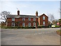
9
Haseley Knob
The cottages by the old crossroads in Haseley Knob. The village has long since been bypassed and the lane to the left, which used to lead to Wroxall has been truncated by the bypass. The well maintained red 'phone box is shown on the OS map.
Image: © David Stowell
Taken: 3 Sep 2005
0.18 miles
10
The Croft, Haseley Knob
This large guest house is situated on the truncated remains of the lane to Wroxall in Haseley Knob.
Image: © David Stowell
Taken: 3 Sep 2005
0.18 miles