IMAGES TAKEN NEAR TO
Birmingham Road, WARWICK, CV35 7ND
Introduction
This page details the photographs taken nearby to Birmingham Road, CV35 7ND by members of the Geograph project.
The Geograph project started in 2005 with the aim of publishing, organising and preserving representative images for every square kilometre of Great Britain, Ireland and the Isle of Man.

There are currently over 7.5m images from over14,400 individuals and you can help contribute to the project by visiting https://www.geograph.org.uk
Image Map
Images are licensed for reuse under creativecommons.org/licenses/by-sa/2.0
Notes
- Clicking on the map will re-center to the selected point.
- The higher the marker number, the further away the image location is from the centre of the postcode.
Image Listing (8 Images Found)
Images are licensed for reuse under creativecommons.org/licenses/by-sa/2.0
Image
Details
Distance
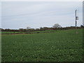
1
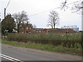
Farm Buildings at Abbey Farm
This track between old brick walls and buildings carries a bridle path through the centre of the farm. The bridle track eventually joins up with the minor road to Nunley Farm.
Image: © Nigel Mykura
Taken: 1 Sep 2012
0.04 miles
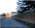
2
Abbey Farm, Wroxall
Showing the patterned brickwork associated with the Wroxall Abbey estate. The view is across the A4177 Birmingham Road, the former A41.
Image: © Robin Stott
Taken: 6 Apr 2010
0.07 miles
3
Abbey Farm, Wroxall
An endangered species in this area – a working farm.
Image: © Robin Stott
Taken: 6 Apr 2010
0.07 miles
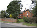
4
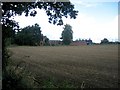
Abbey Farm
Seen from the Birmingham Road across a recently ploughed field.
Image: © David Stowell
Taken: 25 Aug 2005
0.12 miles
5
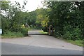
The entrance to Pheasant Lakes Farm, Wroxall
Image: © David Howard
Taken: 1 Aug 2021
0.13 miles
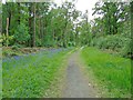
6
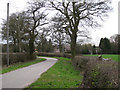
Lane to Wood Corner Farm
The farm, in course of conversion, is at the western corner of the 100-hectare Hay Wood.
Image: © Robin Stott
Taken: 6 Apr 2010
0.19 miles