IMAGES TAKEN NEAR TO
Birmingham Road, WARWICK, CV35 7HF
Introduction
This page details the photographs taken nearby to Birmingham Road, CV35 7HF by members of the Geograph project.
The Geograph project started in 2005 with the aim of publishing, organising and preserving representative images for every square kilometre of Great Britain, Ireland and the Isle of Man.

There are currently over 7.5m images from over14,400 individuals and you can help contribute to the project by visiting https://www.geograph.org.uk
Image Map
Images are licensed for reuse under creativecommons.org/licenses/by-sa/2.0
Notes
- Clicking on the map will re-center to the selected point.
- The higher the marker number, the further away the image location is from the centre of the postcode.
Image Listing (16 Images Found)
Images are licensed for reuse under creativecommons.org/licenses/by-sa/2.0
Image
Details
Distance

2
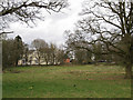
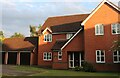
Haseley Hall, Five Ways
Not featured in standard reference works for Warwickshire but is said to have been a late 18th century mansion. It was bought from Sir Edward Antrobus by Sir James Sawyer, an eminent physician. He made extensive additions and occupied it from 1891 until his death in 1919. Then it became a country home for senior staff of W & T Avery Ltd, the weighing machine manufacturer, who vacated it in 1928. By 1930 it was taken over by the Birmingham Society for the Care of Invalid Children; the occupants were girls suffering from "rheumatic hearts". From 1942 it operated as Haseley Hall Residential School for Boys - an open-air school - until its closure in 1974. Its history since then is not yet known but in recent times it appears to have been converted to apartments and small businesses.
Information from James Yardley and the book 'A Breath of Fresh Air: Birmingham's Open-Air Schools 1911-1970' by Frances Wilmot and Pauline Saul, published by Phillimore, 1998.
Image: © Robin Stott
Taken: 27 Mar 2010
0.08 miles
3
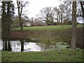
Pond near Haseley Hall
I've been told that this is an old gravel pit.
Image: © Robin Stott
Taken: 27 Mar 2010
0.08 miles
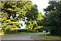
5
Haseley Grange at the junction of Birmingham Road
Image: © David Howard
Taken: 1 Aug 2021
0.10 miles
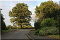
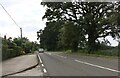
7
Birmingham Road, Five Ways
At the end of Haseley Grange
Image: © David Howard
Taken: 1 Aug 2021
0.12 miles
8
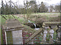
Degraded garden features, Haseley Hall
The small lake shown on OS Explorer is now reduced to a stream, perhaps because of an ad hoc alteration of the weir.
Image: © Robin Stott
Taken: 27 Mar 2010
0.13 miles
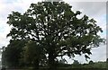
10
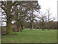
Parkland trees near Haseley Hall Farm
Overmature is the word. North side of Chinn's Wood in the background.
Image: © Robin Stott
Taken: 27 Mar 2010
0.15 miles